You are here: Home > Network List > TA - USArray Transportable Network (new EarthScope stations) Stations List
> Station L61A Hillsdale 1, Hillsdale, NY, USA > Earthquake Result Viewer
L61A Hillsdale 1, Hillsdale, NY, USA - Earthquake Result Viewer
| Earthquake location: |
Guerrero, Mexico |
| Earthquake latitude/longitude: |
17.6/-100.8 |
| Earthquake time(UTC): |
2014/04/18 (108) 14:27:26 GMT |
| Earthquake Depth: |
24 km |
| Earthquake Magnitude: |
7.2 MWW, 7.0 MWB, 7.3 MWC, 7.5 MI |
| Earthquake Catalog/Contributor: |
NEIC PDE/NEIC COMCAT |
|
| Network: |
TA USArray Transportable Network (new EarthScope stations) |
| Station: |
L61A Hillsdale 1, Hillsdale, NY, USA |
| Lat/Lon: |
42.19 N/73.55 W |
| Elevation: |
275 m |
|
| Distance: |
33.8 deg |
| Az: |
37.701 deg |
| Baz: |
231.73 deg |
| Ray Param: |
0.07800003 |
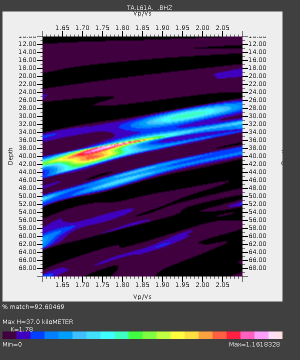
| Estimated Moho Depth: |
37.0 km |
| Estimated Crust Vp/Vs: |
1.78 |
| Assumed Crust Vp: |
6.419 km/s |
| Estimated Crust Vs: |
3.606 km/s |
| Estimated Crust Poisson's Ratio: |
0.27 |
|
| Radial Match: |
92.60469 % |
| Radial Bump: |
327 |
| Transverse Match: |
85.14637 % |
| Transverse Bump: |
400 |
| SOD ConfigId: |
626651 |
| Insert Time: |
2014-05-02 15:09:36.330 +0000 |
| GWidth: |
2.5 |
| Max Bumps: |
400 |
| Tol: |
0.001 |
|

Signal To Noise
| Channel | StoN | STA | LTA |
| TA:L61A: :BHZ:20140418T14:33:36.250015Z | 48.19609 | 1.1461973E-5 | 2.3781958E-7 |
| TA:L61A: :BHN:20140418T14:33:36.250015Z | 20.442862 | 4.8818356E-6 | 2.3880392E-7 |
| TA:L61A: :BHE:20140418T14:33:36.250015Z | 29.513226 | 6.190826E-6 | 2.0976447E-7 |
| Arrivals |
| Ps | 4.9 SECOND |
| PpPs | 15 SECOND |
| PsPs/PpSs | 20 SECOND |


