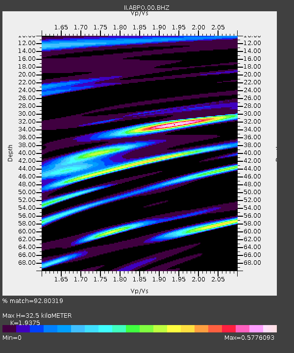
ABPO Ambohimpanompo, Madagascar - Earthquake Result Viewer
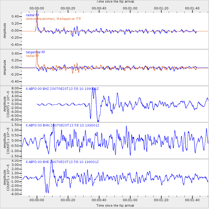
Earthquake location: Philippine Islands Region
Earthquake latitude/longitude: 6.1/127.4
Earthquake time(UTC): 2007/08/20 (232) 13:46:17 GMT
Earthquake Depth: 8.0 km
Earthquake Magnitude: 6.4 MB, 6.2 MS, 6.4 MW, 6.5 ME
Earthquake Catalog/Contributor: WHDF/NEIC
Network: II Global Seismograph Network (GSN - IRIS/IDA)
Station: ABPO Ambohimpanompo, Madagascar
Lat/Lon: 19.02 S/47.23 E
Elevation: 1528 m
Distance: 82.7 deg
Az: 250.001 deg
Baz: 80.98 deg
Ray Param: 0.046686888
Estimated Moho Depth: 32.5 km
Estimated Crust Vp/Vs: 1.94
Assumed Crust Vp: 6.642 km/s
Estimated Crust Vs: 3.428 km/s
Estimated Crust Poisson's Ratio: 0.32
Radial Match: 92.80319 %
Radial Bump: 400
Transverse Match: 73.378006 %
Transverse Bump: 400
SOD ConfigId: 2564
Insert Time: 2010-03-01 21:15:18.836 +0000
GWidth: 2.5
Max Bumps: 400
Tol: 0.001

Signal To Noise

ChannelStoNSTALTA
II:ABPO:00:BHN:20070820T13:58:10.199001Z1.07969074.2849703E-73.9687015E-7
II:ABPO:00:BHE:20070820T13:58:10.199001Z4.42536358.652039E-71.9551024E-7
II:ABPO:00:BHZ:20070820T13:58:10.199001Z6.68065552.221583E-63.3253968E-7
Arrivals
Ps4.7 SECOND
PpPs14 SECOND
PsPs/PpSs19 SECOND