You are here: Home > Network List > TA - USArray Transportable Network (new EarthScope stations) Stations List
> Station L64A Middleborough, MA, USA > Earthquake Result Viewer
L64A Middleborough, MA, USA - Earthquake Result Viewer
| Earthquake location: |
Guerrero, Mexico |
| Earthquake latitude/longitude: |
17.6/-100.8 |
| Earthquake time(UTC): |
2014/04/18 (108) 14:27:26 GMT |
| Earthquake Depth: |
24 km |
| Earthquake Magnitude: |
7.2 MWW, 7.0 MWB, 7.3 MWC, 7.5 MI |
| Earthquake Catalog/Contributor: |
NEIC PDE/NEIC COMCAT |
|
| Network: |
TA USArray Transportable Network (new EarthScope stations) |
| Station: |
L64A Middleborough, MA, USA |
| Lat/Lon: |
41.94 N/70.84 W |
| Elevation: |
17 m |
|
| Distance: |
35.3 deg |
| Az: |
40.179 deg |
| Baz: |
235.583 deg |
| Ray Param: |
0.07726282 |
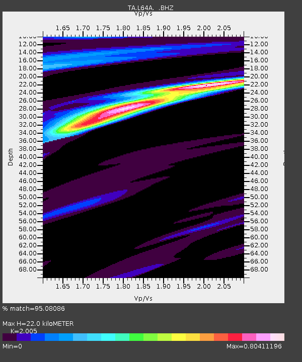
| Estimated Moho Depth: |
22.0 km |
| Estimated Crust Vp/Vs: |
2.01 |
| Assumed Crust Vp: |
6.472 km/s |
| Estimated Crust Vs: |
3.228 km/s |
| Estimated Crust Poisson's Ratio: |
0.33 |
|
| Radial Match: |
95.08086 % |
| Radial Bump: |
306 |
| Transverse Match: |
64.80993 % |
| Transverse Bump: |
400 |
| SOD ConfigId: |
626651 |
| Insert Time: |
2014-05-02 15:09:50.750 +0000 |
| GWidth: |
2.5 |
| Max Bumps: |
400 |
| Tol: |
0.001 |
|

Signal To Noise
| Channel | StoN | STA | LTA |
| TA:L64A: :BHZ:20140418T14:33:48.97499Z | 46.737812 | 1.2945566E-5 | 2.7698272E-7 |
| TA:L64A: :BHN:20140418T14:33:48.97499Z | 22.134363 | 4.925339E-6 | 2.2252001E-7 |
| TA:L64A: :BHE:20140418T14:33:48.97499Z | 27.771439 | 6.8541453E-6 | 2.4680557E-7 |
| Arrivals |
| Ps | 3.7 SECOND |
| PpPs | 9.5 SECOND |
| PsPs/PpSs | 13 SECOND |


