You are here: Home > Network List > II - Global Seismograph Network (GSN - IRIS/IDA) Stations List
> Station ABPO Ambohimpanompo, Madagascar > Earthquake Result Viewer
ABPO Ambohimpanompo, Madagascar - Earthquake Result Viewer
| Earthquake location: |
Java, Indonesia |
| Earthquake latitude/longitude: |
-5.9/107.7 |
| Earthquake time(UTC): |
2007/08/08 (220) 17:04:57 GMT |
| Earthquake Depth: |
291 km |
| Earthquake Magnitude: |
6.1 MB |
| Earthquake Catalog/Contributor: |
WHDF/NEIC |
|
| Network: |
II Global Seismograph Network (GSN - IRIS/IDA) |
| Station: |
ABPO Ambohimpanompo, Madagascar |
| Lat/Lon: |
19.02 S/47.23 E |
| Elevation: |
1528 m |
|
| Distance: |
60.2 deg |
| Az: |
251.565 deg |
| Baz: |
85.911 deg |
| Ray Param: |
0.060718488 |
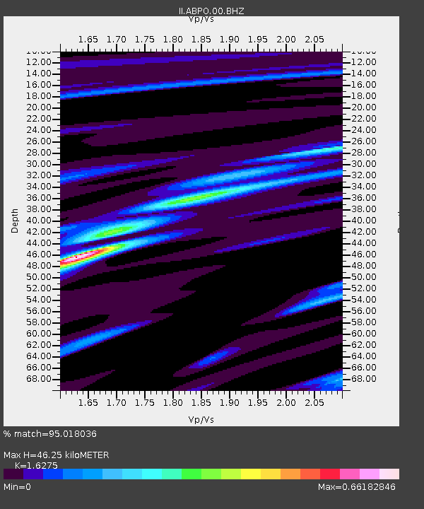
| Estimated Moho Depth: |
46.25 km |
| Estimated Crust Vp/Vs: |
1.63 |
| Assumed Crust Vp: |
6.642 km/s |
| Estimated Crust Vs: |
4.081 km/s |
| Estimated Crust Poisson's Ratio: |
0.20 |
|
| Radial Match: |
95.018036 % |
| Radial Bump: |
237 |
| Transverse Match: |
80.84667 % |
| Transverse Bump: |
400 |
| SOD ConfigId: |
2564 |
| Insert Time: |
2010-03-01 21:15:20.614 +0000 |
| GWidth: |
2.5 |
| Max Bumps: |
400 |
| Tol: |
0.001 |
|

Signal To Noise
| Channel | StoN | STA | LTA |
| II:ABPO:00:BHN:20070808T17:14:04.60001Z | 1.4800099 | 2.7743704E-7 | 1.8745618E-7 |
| II:ABPO:00:BHE:20070808T17:14:04.60001Z | 6.7358594 | 2.2600987E-6 | 3.3553235E-7 |
| II:ABPO:00:BHZ:20070808T17:14:04.60001Z | 14.183828 | 4.8267907E-6 | 3.403024E-7 |
| Arrivals |
| Ps | 4.6 SECOND |
| PpPs | 17 SECOND |
| PsPs/PpSs | 22 SECOND |


