You are here: Home > Network List > TA - USArray Transportable Network (new EarthScope stations) Stations List
> Station M62A Hamden, CT, USA > Earthquake Result Viewer
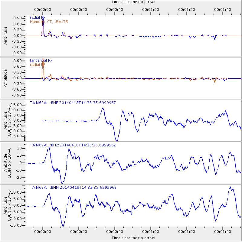
M62A Hamden, CT, USA - Earthquake Result Viewer

| Earthquake location: |
Guerrero, Mexico |
| Earthquake latitude/longitude: |
17.6/-100.8 |
| Earthquake time(UTC): |
2014/04/18 (108) 14:27:26 GMT |
| Earthquake Depth: |
24 km |
| Earthquake Magnitude: |
7.2 MWW, 7.0 MWB, 7.3 MWC, 7.5 MI |
| Earthquake Catalog/Contributor: |
NEIC PDE/NEIC COMCAT |
|
| Network: |
TA USArray Transportable Network (new EarthScope stations) |
| Station: |
M62A Hamden, CT, USA |
| Lat/Lon: |
41.44 N/72.89 W |
| Elevation: |
24 m |
|
| Distance: |
33.8 deg |
| Az: |
39.312 deg |
| Baz: |
233.508 deg |
| Ray Param: |
0.07802921 |
| Estimated Moho Depth: |
25.0 km |
| Estimated Crust Vp/Vs: |
2.10 |
| Assumed Crust Vp: |
6.472 km/s |
| Estimated Crust Vs: |
3.086 km/s |
| Estimated Crust Poisson's Ratio: |
0.35 |
|
| Radial Match: |
94.48934 % |
| Radial Bump: |
187 |
| Transverse Match: |
65.31862 % |
| Transverse Bump: |
400 |
| SOD ConfigId: |
626651 |
| Insert Time: |
2014-05-02 15:10:30.851 +0000 |
| GWidth: |
2.5 |
| Max Bumps: |
400 |
| Tol: |
0.001 |
|
Signal To Noise
| Channel | StoN | STA | LTA |
| TA:M62A: :BHZ:20140418T14:33:35.699996Z | 57.039284 | 1.1862258E-5 | 2.0796648E-7 |
| TA:M62A: :BHN:20140418T14:33:35.699996Z | 18.585876 | 5.3878725E-6 | 2.898907E-7 |
| TA:M62A: :BHE:20140418T14:33:35.699996Z | 40.96256 | 6.7811984E-6 | 1.6554627E-7 |
| Arrivals |
| Ps | 4.5 SECOND |
| PpPs | 11 SECOND |
| PsPs/PpSs | 16 SECOND |


