You are here: Home > Network List > TA - USArray Transportable Network (new EarthScope stations) Stations List
> Station N59A State Game Land 141, Hazleton, PA, USA > Earthquake Result Viewer
N59A State Game Land 141, Hazleton, PA, USA - Earthquake Result Viewer
| Earthquake location: |
Guerrero, Mexico |
| Earthquake latitude/longitude: |
17.6/-100.8 |
| Earthquake time(UTC): |
2014/04/18 (108) 14:27:26 GMT |
| Earthquake Depth: |
24 km |
| Earthquake Magnitude: |
7.2 MWW, 7.0 MWB, 7.3 MWC, 7.5 MI |
| Earthquake Catalog/Contributor: |
NEIC PDE/NEIC COMCAT |
|
| Network: |
TA USArray Transportable Network (new EarthScope stations) |
| Station: |
N59A State Game Land 141, Hazleton, PA, USA |
| Lat/Lon: |
40.92 N/75.77 W |
| Elevation: |
508 m |
|
| Distance: |
31.7 deg |
| Az: |
37.596 deg |
| Baz: |
230.177 deg |
| Ray Param: |
0.07892533 |
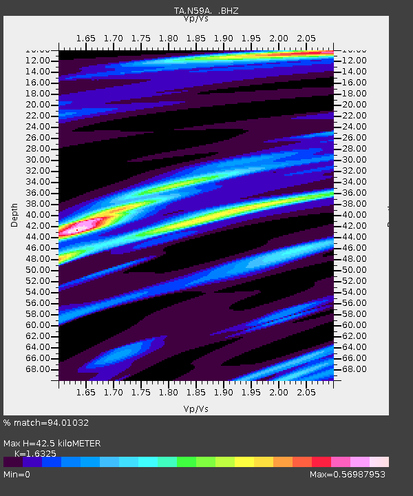
| Estimated Moho Depth: |
42.5 km |
| Estimated Crust Vp/Vs: |
1.63 |
| Assumed Crust Vp: |
6.283 km/s |
| Estimated Crust Vs: |
3.849 km/s |
| Estimated Crust Poisson's Ratio: |
0.20 |
|
| Radial Match: |
94.01032 % |
| Radial Bump: |
245 |
| Transverse Match: |
72.53835 % |
| Transverse Bump: |
400 |
| SOD ConfigId: |
626651 |
| Insert Time: |
2014-05-02 15:11:07.006 +0000 |
| GWidth: |
2.5 |
| Max Bumps: |
400 |
| Tol: |
0.001 |
|
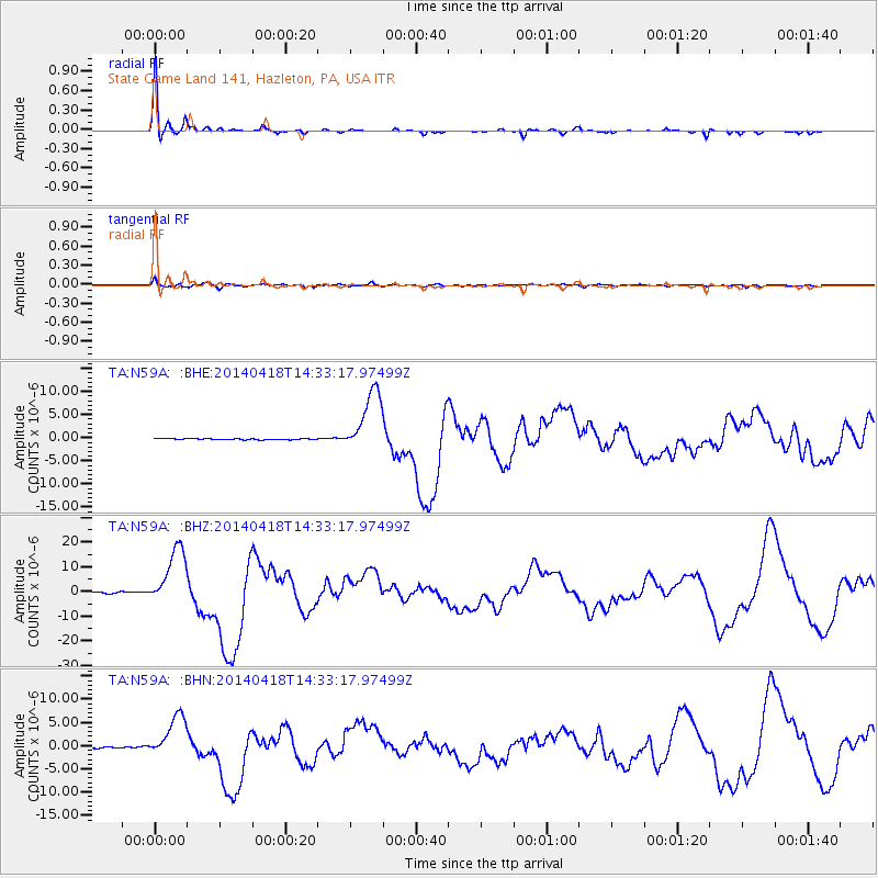
Signal To Noise
| Channel | StoN | STA | LTA |
| TA:N59A: :BHZ:20140418T14:33:17.97499Z | 53.2255 | 1.2024856E-5 | 2.2592285E-7 |
| TA:N59A: :BHN:20140418T14:33:17.97499Z | 34.97888 | 4.6316413E-6 | 1.3241251E-7 |
| TA:N59A: :BHE:20140418T14:33:17.97499Z | 55.761856 | 6.8844597E-6 | 1.234618E-7 |
| Arrivals |
| Ps | 4.6 SECOND |
| PpPs | 16 SECOND |
| PsPs/PpSs | 21 SECOND |


