You are here: Home > Network List > TA - USArray Transportable Network (new EarthScope stations) Stations List
> Station P61A Hammonton, NJ, USA > Earthquake Result Viewer
P61A Hammonton, NJ, USA - Earthquake Result Viewer
| Earthquake location: |
Guerrero, Mexico |
| Earthquake latitude/longitude: |
17.6/-100.8 |
| Earthquake time(UTC): |
2014/04/18 (108) 14:27:26 GMT |
| Earthquake Depth: |
24 km |
| Earthquake Magnitude: |
7.2 MWW, 7.0 MWB, 7.3 MWC, 7.5 MI |
| Earthquake Catalog/Contributor: |
NEIC PDE/NEIC COMCAT |
|
| Network: |
TA USArray Transportable Network (new EarthScope stations) |
| Station: |
P61A Hammonton, NJ, USA |
| Lat/Lon: |
39.67 N/74.79 W |
| Elevation: |
22 m |
|
| Distance: |
31.5 deg |
| Az: |
40.338 deg |
| Baz: |
233.142 deg |
| Ray Param: |
0.07900334 |
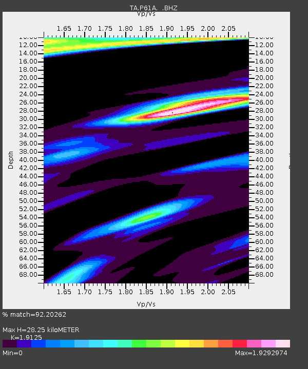
| Estimated Moho Depth: |
28.25 km |
| Estimated Crust Vp/Vs: |
1.91 |
| Assumed Crust Vp: |
6.287 km/s |
| Estimated Crust Vs: |
3.288 km/s |
| Estimated Crust Poisson's Ratio: |
0.31 |
|
| Radial Match: |
92.20262 % |
| Radial Bump: |
400 |
| Transverse Match: |
69.95701 % |
| Transverse Bump: |
400 |
| SOD ConfigId: |
626651 |
| Insert Time: |
2014-05-02 15:11:49.665 +0000 |
| GWidth: |
2.5 |
| Max Bumps: |
400 |
| Tol: |
0.001 |
|
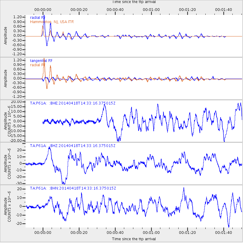
Signal To Noise
| Channel | StoN | STA | LTA |
| TA:P61A: :BHZ:20140418T14:33:16.375015Z | 17.806871 | 1.343263E-5 | 7.5435094E-7 |
| TA:P61A: :BHN:20140418T14:33:16.375015Z | 4.3337784 | 5.8076903E-6 | 1.3400987E-6 |
| TA:P61A: :BHE:20140418T14:33:16.375015Z | 6.3889165 | 8.65651E-6 | 1.3549261E-6 |
| Arrivals |
| Ps | 4.4 SECOND |
| PpPs | 12 SECOND |
| PsPs/PpSs | 17 SECOND |


