You are here: Home > Network List > US - United States National Seismic Network Stations List
> Station COWI Conover, Wisconsin, USA > Earthquake Result Viewer
COWI Conover, Wisconsin, USA - Earthquake Result Viewer

| Earthquake location: |
Guerrero, Mexico |
| Earthquake latitude/longitude: |
17.6/-100.8 |
| Earthquake time(UTC): |
2014/04/18 (108) 14:27:26 GMT |
| Earthquake Depth: |
24 km |
| Earthquake Magnitude: |
7.2 MWW, 7.0 MWB, 7.3 MWC, 7.5 MI |
| Earthquake Catalog/Contributor: |
NEIC PDE/NEIC COMCAT |
|
| Network: |
US United States National Seismic Network |
| Station: |
COWI Conover, Wisconsin, USA |
| Lat/Lon: |
46.10 N/89.14 W |
| Elevation: |
523 m |
|
| Distance: |
30.1 deg |
| Az: |
16.323 deg |
| Baz: |
202.665 deg |
| Ray Param: |
0.07940886 |
| Estimated Moho Depth: |
39.5 km |
| Estimated Crust Vp/Vs: |
1.65 |
| Assumed Crust Vp: |
6.467 km/s |
| Estimated Crust Vs: |
3.925 km/s |
| Estimated Crust Poisson's Ratio: |
0.21 |
|
| Radial Match: |
97.68811 % |
| Radial Bump: |
217 |
| Transverse Match: |
85.19158 % |
| Transverse Bump: |
400 |
| SOD ConfigId: |
626651 |
| Insert Time: |
2014-05-02 15:12:32.734 +0000 |
| GWidth: |
2.5 |
| Max Bumps: |
400 |
| Tol: |
0.001 |
|
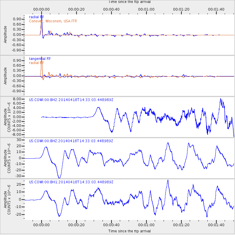
Signal To Noise
| Channel | StoN | STA | LTA |
| US:COWI:00:BHZ:20140418T14:33:03.448989Z | 106.67696 | 1.1941859E-5 | 1.1194412E-7 |
| US:COWI:00:BH1:20140418T14:33:03.448989Z | 46.738377 | 7.75248E-6 | 1.658697E-7 |
| US:COWI:00:BH2:20140418T14:33:03.448989Z | 29.382914 | 2.8530098E-6 | 9.709758E-8 |
| Arrivals |
| Ps | 4.3 SECOND |
| PpPs | 15 SECOND |
| PsPs/PpSs | 19 SECOND |


