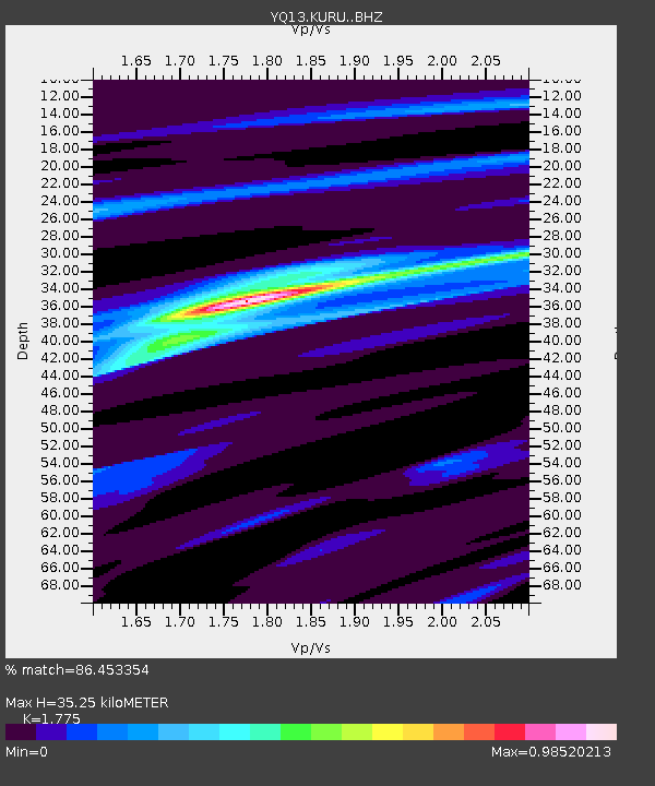
KURU Muhukuru,Tanzania - Earthquake Result Viewer

Earthquake location: Jujuy Province, Argentina
Earthquake latitude/longitude: -23.1/-66.7
Earthquake time(UTC): 2015/02/11 (042) 18:57:22 GMT
Earthquake Depth: 223 km
Earthquake Magnitude: 6.7 MWW, 6.7 MWC, 6.7 MWB, 6.9 MI
Earthquake Catalog/Contributor: NEIC PDE/NEIC COMCAT
Network: YQ Study of Extension and Magmatism in Malawi and Tanzania
Station: KURU Muhukuru,Tanzania
Lat/Lon: 11.20 S/35.46 E
Elevation: 751 m
Distance: 96.6 deg
Az: 105.069 deg
Baz: 244.971 deg
Ray Param: 0.04026679
Estimated Moho Depth: 35.25 km
Estimated Crust Vp/Vs: 1.77
Assumed Crust Vp: 6.502 km/s
Estimated Crust Vs: 3.663 km/s
Estimated Crust Poisson's Ratio: 0.27
Radial Match: 86.453354 %
Radial Bump: 304
Transverse Match: 66.232635 %
Transverse Bump: 400
SOD ConfigId: 7019011
Insert Time: 2019-04-16 18:23:55.856 +0000
GWidth: 2.5
Max Bumps: 400
Tol: 0.001

Signal To Noise

ChannelStoNSTALTA
YQ:KURU: :BHZ:20150211T19:09:55.420012Z1.52093921.5168494E-79.97311E-8
YQ:KURU: :BHN:20150211T19:09:55.420012Z1.20982181.2489855E-71.03237134E-7
YQ:KURU: :BHE:20150211T19:09:55.420012Z0.86098457.8646295E-89.13446E-8
Arrivals
Ps4.3 SECOND
PpPs15 SECOND
PsPs/PpSs19 SECOND