You are here: Home > Network List > US - United States National Seismic Network Stations List
> Station LONY Lake Ozonia, New York, USA > Earthquake Result Viewer
LONY Lake Ozonia, New York, USA - Earthquake Result Viewer
| Earthquake location: |
Guerrero, Mexico |
| Earthquake latitude/longitude: |
17.6/-100.8 |
| Earthquake time(UTC): |
2014/04/18 (108) 14:27:26 GMT |
| Earthquake Depth: |
24 km |
| Earthquake Magnitude: |
7.2 MWW, 7.0 MWB, 7.3 MWC, 7.5 MI |
| Earthquake Catalog/Contributor: |
NEIC PDE/NEIC COMCAT |
|
| Network: |
US United States National Seismic Network |
| Station: |
LONY Lake Ozonia, New York, USA |
| Lat/Lon: |
44.62 N/74.58 W |
| Elevation: |
440 m |
|
| Distance: |
34.8 deg |
| Az: |
33.561 deg |
| Baz: |
227.606 deg |
| Ray Param: |
0.07750959 |
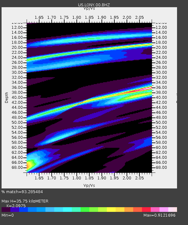
| Estimated Moho Depth: |
35.75 km |
| Estimated Crust Vp/Vs: |
2.10 |
| Assumed Crust Vp: |
6.419 km/s |
| Estimated Crust Vs: |
3.06 km/s |
| Estimated Crust Poisson's Ratio: |
0.35 |
|
| Radial Match: |
93.285484 % |
| Radial Bump: |
317 |
| Transverse Match: |
93.5275 % |
| Transverse Bump: |
386 |
| SOD ConfigId: |
626651 |
| Insert Time: |
2014-05-02 15:13:04.025 +0000 |
| GWidth: |
2.5 |
| Max Bumps: |
400 |
| Tol: |
0.001 |
|
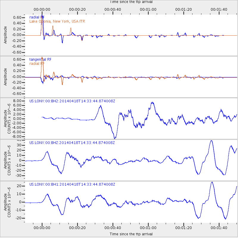
Signal To Noise
| Channel | StoN | STA | LTA |
| US:LONY:00:BHZ:20140418T14:33:44.874008Z | 43.650875 | 1.0479595E-5 | 2.4007755E-7 |
| US:LONY:00:BH1:20140418T14:33:44.874008Z | 26.739738 | 5.993505E-6 | 2.2414224E-7 |
| US:LONY:00:BH2:20140418T14:33:44.874008Z | 9.596098 | 3.2901871E-6 | 3.428672E-7 |
| Arrivals |
| Ps | 6.5 SECOND |
| PpPs | 16 SECOND |
| PsPs/PpSs | 23 SECOND |


