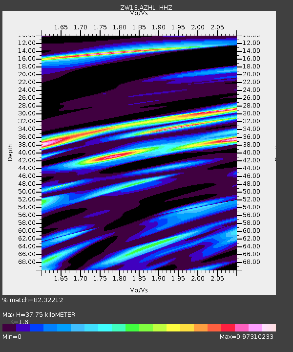
AZHL Azle B1 - Earthquake Result Viewer

Earthquake location: Jujuy Province, Argentina
Earthquake latitude/longitude: -23.1/-66.7
Earthquake time(UTC): 2015/02/11 (042) 18:57:22 GMT
Earthquake Depth: 223 km
Earthquake Magnitude: 6.7 MWW, 6.7 MWC, 6.7 MWB, 6.9 MI
Earthquake Catalog/Contributor: NEIC PDE/NEIC COMCAT
Network: ZW Locating North Texas Earthquakes
Station: AZHL Azle B1
Lat/Lon: 32.97 N/97.35 W
Elevation: 222 m
Distance: 63.0 deg
Az: 331.234 deg
Baz: 148.193 deg
Ray Param: 0.059188526
Estimated Moho Depth: 37.75 km
Estimated Crust Vp/Vs: 1.60
Assumed Crust Vp: 6.38 km/s
Estimated Crust Vs: 3.988 km/s
Estimated Crust Poisson's Ratio: 0.18
Radial Match: 82.32212 %
Radial Bump: 400
Transverse Match: 51.11516 %
Transverse Bump: 400
SOD ConfigId: 7019011
Insert Time: 2019-04-16 18:24:33.663 +0000
GWidth: 2.5
Max Bumps: 400
Tol: 0.001

Signal To Noise

ChannelStoNSTALTA
ZW:AZHL: :HHZ:20150211T19:06:54.360015Z22.7048365.892681E-62.595342E-7
ZW:AZHL: :HHN:20150211T19:06:54.360015Z6.10935742.383924E-63.9020867E-7
ZW:AZHL: :HHE:20150211T19:06:54.360015Z1.94623761.3633385E-67.004995E-7
Arrivals
Ps3.7 SECOND
PpPs15 SECOND
PsPs/PpSs18 SECOND