LON Longmire (broad-band and DWWSSN) - Earthquake Result Viewer
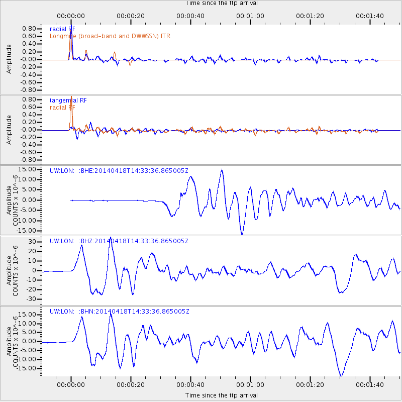
Earthquake location: Guerrero, Mexico
Earthquake latitude/longitude: 17.6/-100.8
Earthquake time(UTC): 2014/04/18 (108) 14:27:26 GMT
Earthquake Depth: 24 km
Earthquake Magnitude: 7.2 MWW, 7.0 MWB, 7.3 MWC, 7.5 MI
Earthquake Catalog/Contributor: NEIC PDE/NEIC COMCAT
Network: UW Pacific Northwest Regional Seismic Network
Station: LON Longmire (broad-band and DWWSSN)
Lat/Lon: 46.75 N/121.81 W
Elevation: 850 m
Distance: 33.9 deg
Az: 333.782 deg
Baz: 142.197 deg
Ray Param: 0.07796738
Estimated Moho Depth: 32.75 km
Estimated Crust Vp/Vs: 2.00
Assumed Crust Vp: 6.597 km/s
Estimated Crust Vs: 3.295 km/s
Estimated Crust Poisson's Ratio: 0.33
Radial Match: 93.98538 %
Radial Bump: 280
Transverse Match: 91.70996 %
Transverse Bump: 400
SOD ConfigId: 626651
Insert Time: 2014-05-02 15:14:31.106 +0000
GWidth: 2.5
Max Bumps: 400
Tol: 0.001

Signal To Noise

ChannelStoNSTALTA
UW:LON: :BHZ:20140418T14:33:36.865005Z54.3557931.3883343E-52.5541607E-7
UW:LON: :BHN:20140418T14:33:36.865005Z58.779737.4405416E-61.2658346E-7
UW:LON: :BHE:20140418T14:33:36.865005Z55.305064.3324726E-67.833773E-8
Arrivals
Ps5.3 SECOND
PpPs14 SECOND
PsPs/PpSs19 SECOND