You are here: Home > Network List > UW - Pacific Northwest Regional Seismic Network Stations List
> Station YACT Amboy, WA, USA > Earthquake Result Viewer
YACT Amboy, WA, USA - Earthquake Result Viewer

| Earthquake location: |
Guerrero, Mexico |
| Earthquake latitude/longitude: |
17.6/-100.8 |
| Earthquake time(UTC): |
2014/04/18 (108) 14:27:26 GMT |
| Earthquake Depth: |
24 km |
| Earthquake Magnitude: |
7.2 MWW, 7.0 MWB, 7.3 MWC, 7.5 MI |
| Earthquake Catalog/Contributor: |
NEIC PDE/NEIC COMCAT |
|
| Network: |
UW Pacific Northwest Regional Seismic Network |
| Station: |
YACT Amboy, WA, USA |
| Lat/Lon: |
45.93 N/122.42 W |
| Elevation: |
211 m |
|
| Distance: |
33.5 deg |
| Az: |
332.268 deg |
| Baz: |
140.498 deg |
| Ray Param: |
0.07813995 |
| Estimated Moho Depth: |
10.0 km |
| Estimated Crust Vp/Vs: |
1.76 |
| Assumed Crust Vp: |
6.566 km/s |
| Estimated Crust Vs: |
3.72 km/s |
| Estimated Crust Poisson's Ratio: |
0.26 |
|
| Radial Match: |
92.81206 % |
| Radial Bump: |
400 |
| Transverse Match: |
65.662254 % |
| Transverse Bump: |
400 |
| SOD ConfigId: |
626651 |
| Insert Time: |
2014-05-02 15:15:27.644 +0000 |
| GWidth: |
2.5 |
| Max Bumps: |
400 |
| Tol: |
0.001 |
|
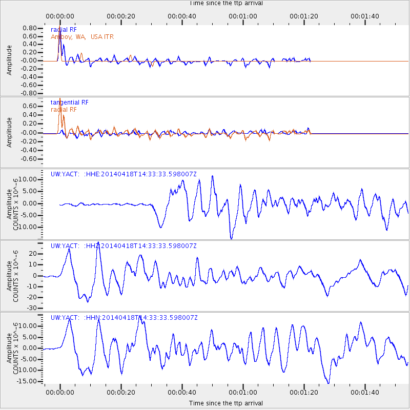
Signal To Noise
| Channel | StoN | STA | LTA |
| UW:YACT: :HHZ:20140418T14:33:33.598007Z | 52.609848 | 1.2935949E-5 | 2.4588456E-7 |
| UW:YACT: :HHN:20140418T14:33:33.598007Z | 28.05369 | 7.0395367E-6 | 2.5093087E-7 |
| UW:YACT: :HHE:20140418T14:33:33.598007Z | 19.981628 | 5.5995206E-6 | 2.8023348E-7 |
| Arrivals |
| Ps | 1.3 SECOND |
| PpPs | 3.9 SECOND |
| PsPs/PpSs | 5.1 SECOND |


