You are here: Home > Network List > UW - Pacific Northwest Regional Seismic Network Stations List
> Station PASS Maple Falls, WA, USA > Earthquake Result Viewer
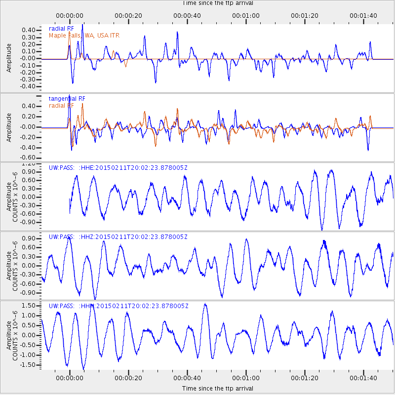
PASS Maple Falls, WA, USA - Earthquake Result Viewer
*The percent match for this event was below the threshold and hence no stack was calculated.
| Earthquake location: |
Near North Coast Of Irian Jaya |
| Earthquake latitude/longitude: |
-2.7/139.0 |
| Earthquake time(UTC): |
2015/02/11 (042) 19:49:23 GMT |
| Earthquake Depth: |
37 km |
| Earthquake Magnitude: |
4.7 mb |
| Earthquake Catalog/Contributor: |
ISC/ISC |
|
| Network: |
UW Pacific Northwest Regional Seismic Network |
| Station: |
PASS Maple Falls, WA, USA |
| Lat/Lon: |
49.00 N/122.09 W |
| Elevation: |
174 m |
|
| Distance: |
97.8 deg |
| Az: |
41.057 deg |
| Baz: |
274.961 deg |
| Ray Param: |
$rayparam |
*The percent match for this event was below the threshold and hence was not used in the summary stack. |
|
| Radial Match: |
62.09436 % |
| Radial Bump: |
400 |
| Transverse Match: |
60.07664 % |
| Transverse Bump: |
379 |
| SOD ConfigId: |
7019011 |
| Insert Time: |
2019-04-16 18:28:48.010 +0000 |
| GWidth: |
2.5 |
| Max Bumps: |
400 |
| Tol: |
0.001 |
|
Signal To Noise
| Channel | StoN | STA | LTA |
| UW:PASS: :HHZ:20150211T20:02:23.878005Z | 2.16282 | 6.766518E-7 | 3.1285626E-7 |
| UW:PASS: :HHN:20150211T20:02:23.878005Z | 2.6961365 | 1.0026603E-6 | 3.718878E-7 |
| UW:PASS: :HHE:20150211T20:02:23.878005Z | 0.5780457 | 2.3507864E-7 | 4.066783E-7 |
| Arrivals |
| Ps | |
| PpPs | |
| PsPs/PpSs | |


