You are here: Home > Network List > AV - Alaska Volcano Observatory Stations List
> Station MAPS Pakushin Southeast, Makushin Volcano, Alaska > Earthquake Result Viewer
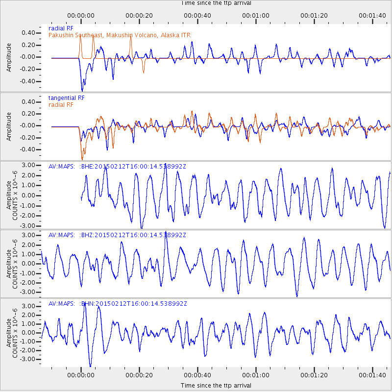
MAPS Pakushin Southeast, Makushin Volcano, Alaska - Earthquake Result Viewer
*The percent match for this event was below the threshold and hence no stack was calculated.
| Earthquake location: |
Near Coast Of Jalisco, Mexico |
| Earthquake latitude/longitude: |
19.2/-105.9 |
| Earthquake time(UTC): |
2015/02/12 (043) 15:50:57 GMT |
| Earthquake Depth: |
30 km |
| Earthquake Magnitude: |
5.5 MW |
| Earthquake Catalog/Contributor: |
ISC/ISC |
|
| Network: |
AV Alaska Volcano Observatory |
| Station: |
MAPS Pakushin Southeast, Makushin Volcano, Alaska |
| Lat/Lon: |
53.81 N/166.94 W |
| Elevation: |
333 m |
|
| Distance: |
57.7 deg |
| Az: |
322.109 deg |
| Baz: |
101.893 deg |
| Ray Param: |
$rayparam |
*The percent match for this event was below the threshold and hence was not used in the summary stack. |
|
| Radial Match: |
42.894142 % |
| Radial Bump: |
400 |
| Transverse Match: |
49.24413 % |
| Transverse Bump: |
400 |
| SOD ConfigId: |
7019011 |
| Insert Time: |
2019-04-16 18:33:16.659 +0000 |
| GWidth: |
2.5 |
| Max Bumps: |
400 |
| Tol: |
0.001 |
|
Signal To Noise
| Channel | StoN | STA | LTA |
| AV:MAPS: :BHZ:20150212T16:00:14.538992Z | 0.793885 | 9.832149E-7 | 1.2384853E-6 |
| AV:MAPS: :BHN:20150212T16:00:14.538992Z | 2.573813 | 2.0196023E-6 | 7.846733E-7 |
| AV:MAPS: :BHE:20150212T16:00:14.538992Z | 1.2005543 | 1.7032493E-6 | 1.4187192E-6 |
| Arrivals |
| Ps | |
| PpPs | |
| PsPs/PpSs | |


