You are here: Home > Network List > NE - New England Seismic Network Stations List
> Station EMMW Machias, ME, USA > Earthquake Result Viewer
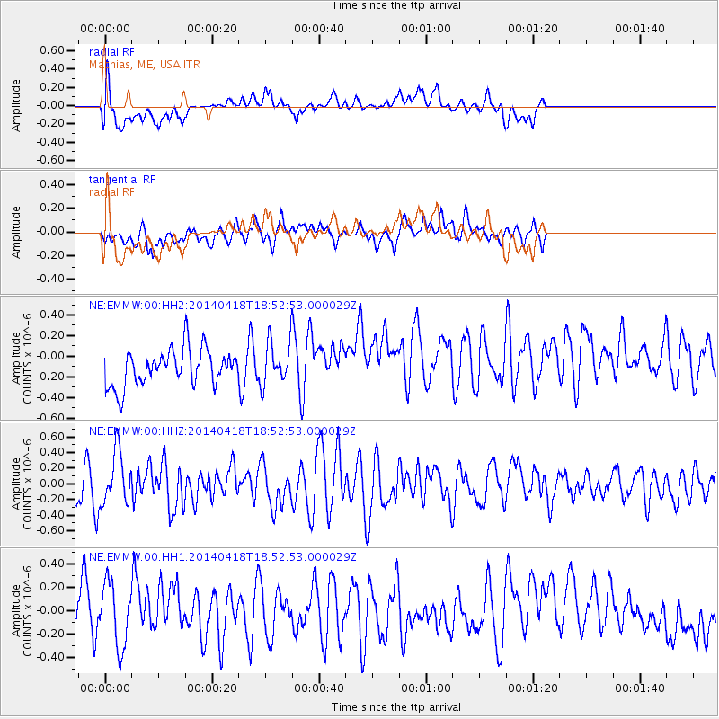
EMMW Machias, ME, USA - Earthquake Result Viewer
*The percent match for this event was below the threshold and hence no stack was calculated.
| Earthquake location: |
Northern Alaska |
| Earthquake latitude/longitude: |
67.7/-162.5 |
| Earthquake time(UTC): |
2014/04/18 (108) 18:44:17 GMT |
| Earthquake Depth: |
1.0 km |
| Earthquake Magnitude: |
5.5 MB, 5.4 MI |
| Earthquake Catalog/Contributor: |
NEIC PDE/NEIC COMCAT |
|
| Network: |
NE New England Seismic Network |
| Station: |
EMMW Machias, ME, USA |
| Lat/Lon: |
44.71 N/67.46 W |
| Elevation: |
35 m |
|
| Distance: |
51.4 deg |
| Az: |
65.368 deg |
| Baz: |
330.847 deg |
| Ray Param: |
$rayparam |
*The percent match for this event was below the threshold and hence was not used in the summary stack. |
|
| Radial Match: |
67.24488 % |
| Radial Bump: |
400 |
| Transverse Match: |
40.63248 % |
| Transverse Bump: |
400 |
| SOD ConfigId: |
626651 |
| Insert Time: |
2014-05-02 19:25:49.838 +0000 |
| GWidth: |
2.5 |
| Max Bumps: |
400 |
| Tol: |
0.001 |
|
Signal To Noise
| Channel | StoN | STA | LTA |
| NE:EMMW:00:HHZ:20140418T18:52:53.000029Z | 1.6807115 | 3.3206965E-7 | 1.9757681E-7 |
| NE:EMMW:00:HH1:20140418T18:52:53.000029Z | 1.4607245 | 2.7314707E-7 | 1.8699424E-7 |
| NE:EMMW:00:HH2:20140418T18:52:53.000029Z | 1.1808308 | 2.0763584E-7 | 1.7583876E-7 |
| Arrivals |
| Ps | |
| PpPs | |
| PsPs/PpSs | |


