You are here: Home > Network List > IU - Global Seismograph Network (GSN - IRIS/USGS) Stations List
> Station CTAO Charters Towers, Australia > Earthquake Result Viewer
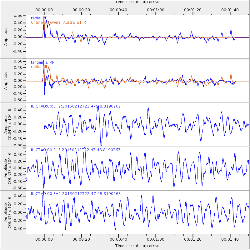
CTAO Charters Towers, Australia - Earthquake Result Viewer
*The percent match for this event was below the threshold and hence no stack was calculated.
| Earthquake location: |
Kuril Islands |
| Earthquake latitude/longitude: |
44.1/146.4 |
| Earthquake time(UTC): |
2015/02/12 (043) 22:38:02 GMT |
| Earthquake Depth: |
146 km |
| Earthquake Magnitude: |
3.5 mb |
| Earthquake Catalog/Contributor: |
ISC/ISC |
|
| Network: |
IU Global Seismograph Network (GSN - IRIS/USGS) |
| Station: |
CTAO Charters Towers, Australia |
| Lat/Lon: |
20.09 S/146.25 E |
| Elevation: |
357 m |
|
| Distance: |
63.9 deg |
| Az: |
180.129 deg |
| Baz: |
0.099 deg |
| Ray Param: |
$rayparam |
*The percent match for this event was below the threshold and hence was not used in the summary stack. |
|
| Radial Match: |
62.6338 % |
| Radial Bump: |
400 |
| Transverse Match: |
56.354343 % |
| Transverse Bump: |
400 |
| SOD ConfigId: |
7019011 |
| Insert Time: |
2019-04-16 18:42:51.853 +0000 |
| GWidth: |
2.5 |
| Max Bumps: |
400 |
| Tol: |
0.001 |
|
Signal To Noise
| Channel | StoN | STA | LTA |
| IU:CTAO:00:BHZ:20150212T22:47:48.819026Z | 1.1514531 | 3.0183884E-7 | 2.6213732E-7 |
| IU:CTAO:00:BH1:20150212T22:47:48.819026Z | 0.994098 | 2.3157011E-7 | 2.3294496E-7 |
| IU:CTAO:00:BH2:20150212T22:47:48.819026Z | 2.0451758 | 3.2801657E-7 | 1.6038551E-7 |
| Arrivals |
| Ps | |
| PpPs | |
| PsPs/PpSs | |


