You are here: Home > Network List > TA - USArray Transportable Network (new EarthScope stations) Stations List
> Station M50A Fremont, OH, USA > Earthquake Result Viewer
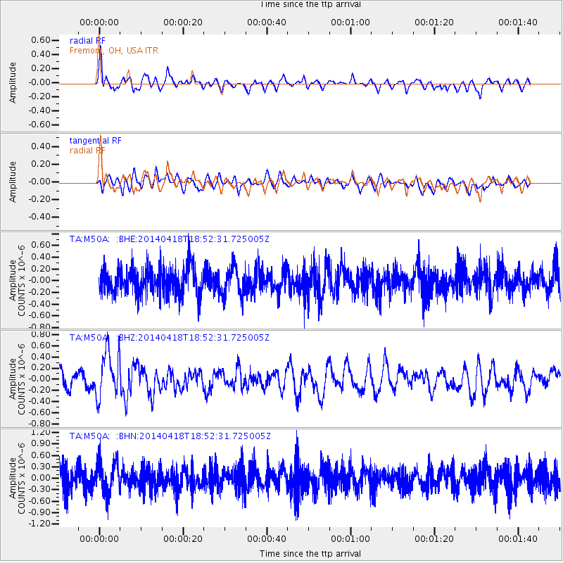
M50A Fremont, OH, USA - Earthquake Result Viewer
*The percent match for this event was below the threshold and hence no stack was calculated.
| Earthquake location: |
Northern Alaska |
| Earthquake latitude/longitude: |
67.7/-162.5 |
| Earthquake time(UTC): |
2014/04/18 (108) 18:44:17 GMT |
| Earthquake Depth: |
1.0 km |
| Earthquake Magnitude: |
5.5 MB, 5.4 MI |
| Earthquake Catalog/Contributor: |
NEIC PDE/NEIC COMCAT |
|
| Network: |
TA USArray Transportable Network (new EarthScope stations) |
| Station: |
M50A Fremont, OH, USA |
| Lat/Lon: |
41.40 N/83.04 W |
| Elevation: |
176 m |
|
| Distance: |
48.6 deg |
| Az: |
80.45 deg |
| Baz: |
329.937 deg |
| Ray Param: |
$rayparam |
*The percent match for this event was below the threshold and hence was not used in the summary stack. |
|
| Radial Match: |
53.141075 % |
| Radial Bump: |
400 |
| Transverse Match: |
44.353207 % |
| Transverse Bump: |
400 |
| SOD ConfigId: |
626651 |
| Insert Time: |
2014-05-02 19:38:14.924 +0000 |
| GWidth: |
2.5 |
| Max Bumps: |
400 |
| Tol: |
0.001 |
|
Signal To Noise
| Channel | StoN | STA | LTA |
| TA:M50A: :BHZ:20140418T18:52:31.725005Z | 2.7341962 | 4.25456E-7 | 1.556055E-7 |
| TA:M50A: :BHN:20140418T18:52:31.725005Z | 1.2776486 | 4.500392E-7 | 3.5224022E-7 |
| TA:M50A: :BHE:20140418T18:52:31.725005Z | 1.0878574 | 2.5905302E-7 | 2.3813145E-7 |
| Arrivals |
| Ps | |
| PpPs | |
| PsPs/PpSs | |


