You are here: Home > Network List > TA - USArray Transportable Network (new EarthScope stations) Stations List
> Station R53A Hurricane, WV, USA > Earthquake Result Viewer
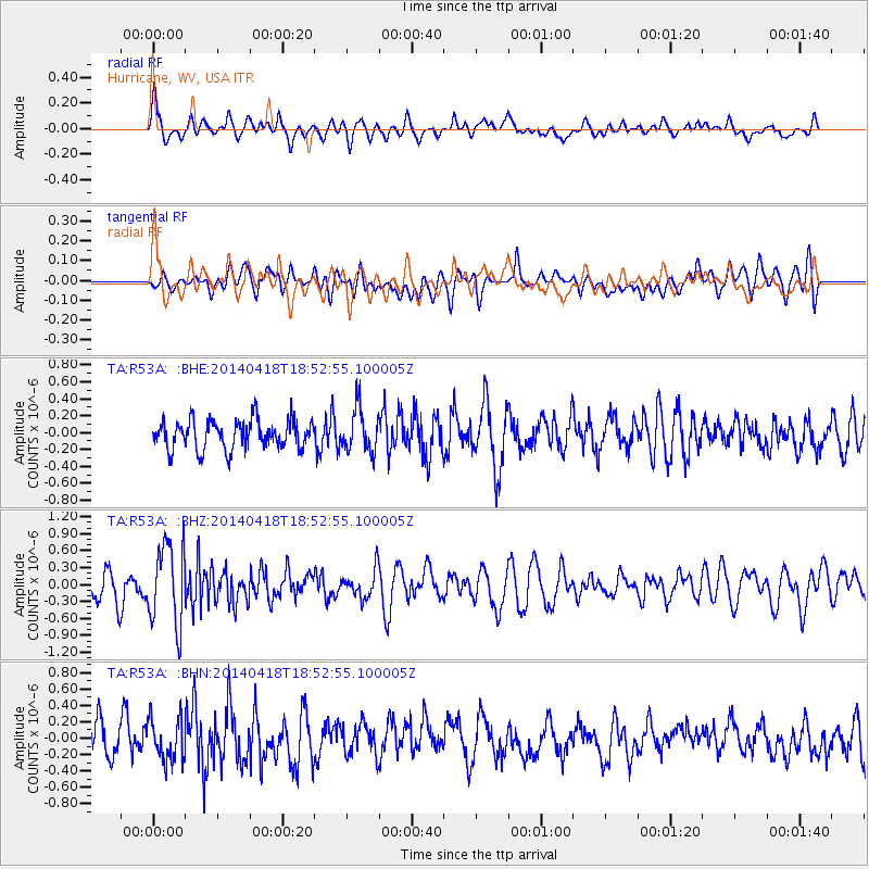
R53A Hurricane, WV, USA - Earthquake Result Viewer
*The percent match for this event was below the threshold and hence no stack was calculated.
| Earthquake location: |
Northern Alaska |
| Earthquake latitude/longitude: |
67.7/-162.5 |
| Earthquake time(UTC): |
2014/04/18 (108) 18:44:17 GMT |
| Earthquake Depth: |
1.0 km |
| Earthquake Magnitude: |
5.5 MB, 5.4 MI |
| Earthquake Catalog/Contributor: |
NEIC PDE/NEIC COMCAT |
|
| Network: |
TA USArray Transportable Network (new EarthScope stations) |
| Station: |
R53A Hurricane, WV, USA |
| Lat/Lon: |
38.33 N/81.95 W |
| Elevation: |
294 m |
|
| Distance: |
51.7 deg |
| Az: |
81.458 deg |
| Baz: |
331.281 deg |
| Ray Param: |
$rayparam |
*The percent match for this event was below the threshold and hence was not used in the summary stack. |
|
| Radial Match: |
56.65365 % |
| Radial Bump: |
400 |
| Transverse Match: |
49.46979 % |
| Transverse Bump: |
400 |
| SOD ConfigId: |
626651 |
| Insert Time: |
2014-05-02 19:41:49.099 +0000 |
| GWidth: |
2.5 |
| Max Bumps: |
400 |
| Tol: |
0.001 |
|
Signal To Noise
| Channel | StoN | STA | LTA |
| TA:R53A: :BHZ:20140418T18:52:55.100005Z | 2.589374 | 7.122067E-7 | 2.7504973E-7 |
| TA:R53A: :BHN:20140418T18:52:55.100005Z | 1.462306 | 2.5745916E-7 | 1.7606382E-7 |
| TA:R53A: :BHE:20140418T18:52:55.100005Z | 1.4856822 | 2.5631329E-7 | 1.7252228E-7 |
| Arrivals |
| Ps | |
| PpPs | |
| PsPs/PpSs | |


