You are here: Home > Network List > IU - Global Seismograph Network (GSN - IRIS/USGS) Stations List
> Station ULN Ulaanbaatar, Mongolia > Earthquake Result Viewer
ULN Ulaanbaatar, Mongolia - Earthquake Result Viewer
| Earthquake location: |
Solomon Islands |
| Earthquake latitude/longitude: |
-6.7/155.1 |
| Earthquake time(UTC): |
2014/04/19 (109) 01:04:03 GMT |
| Earthquake Depth: |
24 km |
| Earthquake Magnitude: |
6.6 MWB, 6.9 MI, 7.0 MI |
| Earthquake Catalog/Contributor: |
NEIC PDE/NEIC COMCAT |
|
| Network: |
IU Global Seismograph Network (GSN - IRIS/USGS) |
| Station: |
ULN Ulaanbaatar, Mongolia |
| Lat/Lon: |
47.87 N/107.05 E |
| Elevation: |
1610 m |
|
| Distance: |
68.8 deg |
| Az: |
327.517 deg |
| Baz: |
127.606 deg |
| Ray Param: |
0.05604548 |
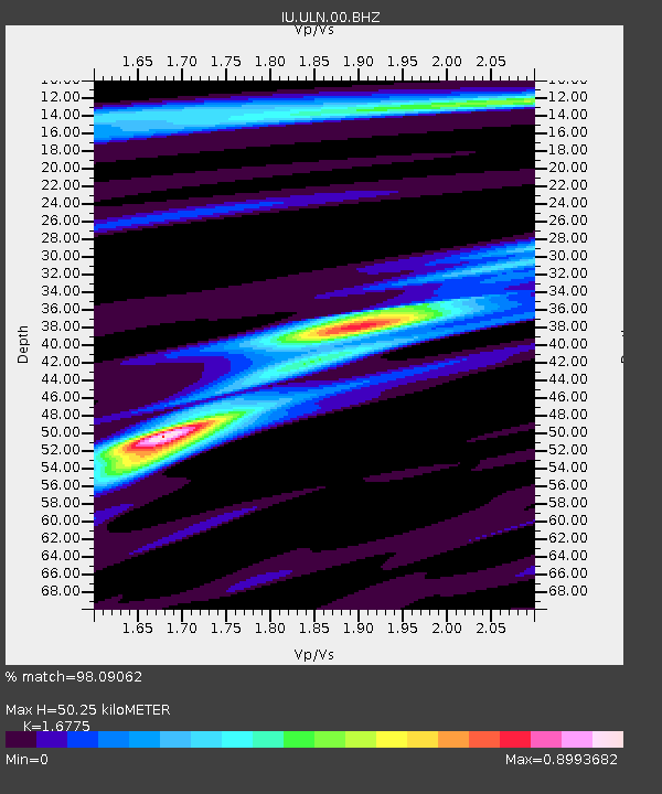
| Estimated Moho Depth: |
50.25 km |
| Estimated Crust Vp/Vs: |
1.68 |
| Assumed Crust Vp: |
6.642 km/s |
| Estimated Crust Vs: |
3.959 km/s |
| Estimated Crust Poisson's Ratio: |
0.22 |
|
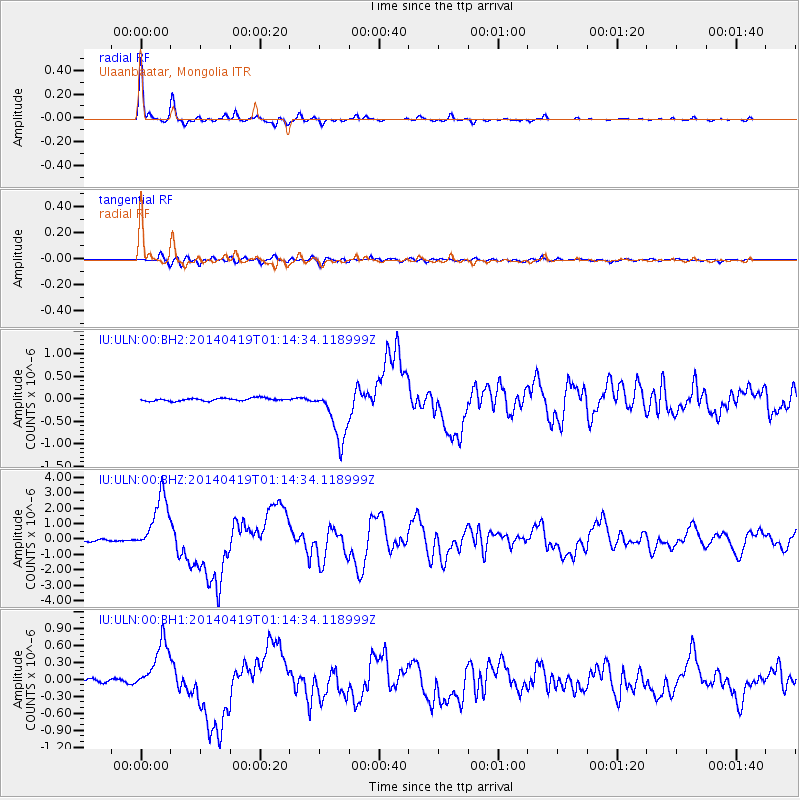
| Radial Match: |
98.09062 % |
| Radial Bump: |
239 |
| Transverse Match: |
83.60206 % |
| Transverse Bump: |
400 |
| SOD ConfigId: |
626651 |
| Insert Time: |
2014-05-03 01:22:27.209 +0000 |
| GWidth: |
2.5 |
| Max Bumps: |
400 |
| Tol: |
0.001 |
|
Signal To Noise
| Channel | StoN | STA | LTA |
| IU:ULN:00:BHZ:20140419T01:14:34.118999Z | 44.149357 | 1.8695895E-6 | 4.2346926E-8 |
| IU:ULN:00:BH1:20140419T01:14:34.118999Z | 13.933508 | 4.63881E-7 | 3.3292476E-8 |
| IU:ULN:00:BH2:20140419T01:14:34.118999Z | 19.410282 | 5.9883007E-7 | 3.085118E-8 |
| Arrivals |
| Ps | 5.4 SECOND |
| PpPs | 19 SECOND |
| PsPs/PpSs | 25 SECOND |


