You are here: Home > Network List > IU - Global Seismograph Network (GSN - IRIS/USGS) Stations List
> Station XMAS Kiritimati Island, Republic of Kiribati > Earthquake Result Viewer
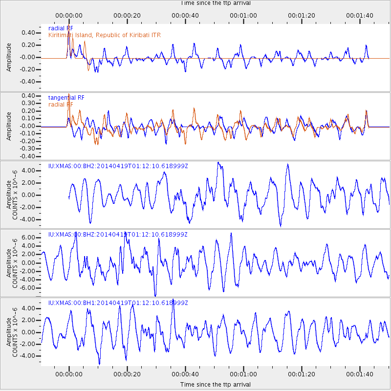
XMAS Kiritimati Island, Republic of Kiribati - Earthquake Result Viewer
*The percent match for this event was below the threshold and hence no stack was calculated.
| Earthquake location: |
Solomon Islands |
| Earthquake latitude/longitude: |
-6.7/155.1 |
| Earthquake time(UTC): |
2014/04/19 (109) 01:04:03 GMT |
| Earthquake Depth: |
24 km |
| Earthquake Magnitude: |
6.6 MWB, 6.9 MI, 7.0 MI |
| Earthquake Catalog/Contributor: |
NEIC PDE/NEIC COMCAT |
|
| Network: |
IU Global Seismograph Network (GSN - IRIS/USGS) |
| Station: |
XMAS Kiritimati Island, Republic of Kiribati |
| Lat/Lon: |
2.04 N/157.45 W |
| Elevation: |
20 m |
|
| Distance: |
48.2 deg |
| Az: |
81.257 deg |
| Baz: |
259.228 deg |
| Ray Param: |
$rayparam |
*The percent match for this event was below the threshold and hence was not used in the summary stack. |
|
| Radial Match: |
66.021866 % |
| Radial Bump: |
400 |
| Transverse Match: |
45.439064 % |
| Transverse Bump: |
400 |
| SOD ConfigId: |
626651 |
| Insert Time: |
2014-05-03 01:22:57.199 +0000 |
| GWidth: |
2.5 |
| Max Bumps: |
400 |
| Tol: |
0.001 |
|
Signal To Noise
| Channel | StoN | STA | LTA |
| IU:XMAS:00:BHZ:20140419T01:12:10.618999Z | 2.459648 | 3.6391043E-6 | 1.4795224E-6 |
| IU:XMAS:00:BH1:20140419T01:12:10.618999Z | 1.0337168 | 1.9564277E-6 | 1.8926148E-6 |
| IU:XMAS:00:BH2:20140419T01:12:10.618999Z | 1.4134654 | 2.2759853E-6 | 1.6102164E-6 |
| Arrivals |
| Ps | |
| PpPs | |
| PsPs/PpSs | |


