You are here: Home > Network List > TA - USArray Transportable Network (new EarthScope stations) Stations List
> Station A04D Lummi Island, WA, USA > Earthquake Result Viewer
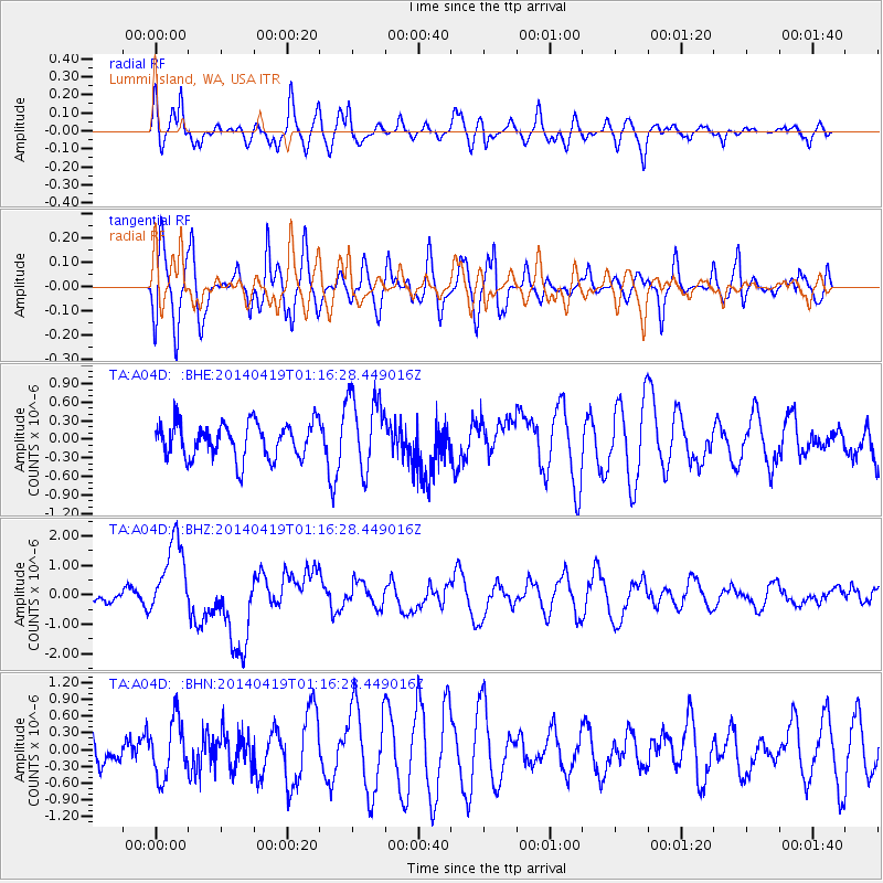
A04D Lummi Island, WA, USA - Earthquake Result Viewer
*The percent match for this event was below the threshold and hence no stack was calculated.
| Earthquake location: |
Solomon Islands |
| Earthquake latitude/longitude: |
-6.7/155.1 |
| Earthquake time(UTC): |
2014/04/19 (109) 01:04:03 GMT |
| Earthquake Depth: |
24 km |
| Earthquake Magnitude: |
6.6 MWB, 6.9 MI, 7.0 MI |
| Earthquake Catalog/Contributor: |
NEIC PDE/NEIC COMCAT |
|
| Network: |
TA USArray Transportable Network (new EarthScope stations) |
| Station: |
A04D Lummi Island, WA, USA |
| Lat/Lon: |
48.72 N/122.71 W |
| Elevation: |
13 m |
|
| Distance: |
89.9 deg |
| Az: |
41.005 deg |
| Baz: |
259.781 deg |
| Ray Param: |
$rayparam |
*The percent match for this event was below the threshold and hence was not used in the summary stack. |
|
| Radial Match: |
53.96286 % |
| Radial Bump: |
400 |
| Transverse Match: |
63.821037 % |
| Transverse Bump: |
400 |
| SOD ConfigId: |
626651 |
| Insert Time: |
2014-05-03 01:27:36.264 +0000 |
| GWidth: |
2.5 |
| Max Bumps: |
400 |
| Tol: |
0.001 |
|
Signal To Noise
| Channel | StoN | STA | LTA |
| TA:A04D: :BHZ:20140419T01:16:28.449016Z | 5.0720224 | 1.327939E-6 | 2.6181647E-7 |
| TA:A04D: :BHN:20140419T01:16:28.449016Z | 1.2794417 | 5.105559E-7 | 3.9904583E-7 |
| TA:A04D: :BHE:20140419T01:16:28.449016Z | 2.1365597 | 6.0808986E-7 | 2.8461167E-7 |
| Arrivals |
| Ps | |
| PpPs | |
| PsPs/PpSs | |


