You are here: Home > Network List > TA - USArray Transportable Network (new EarthScope stations) Stations List
> Station C36M Paulatuk, NT, CAN > Earthquake Result Viewer
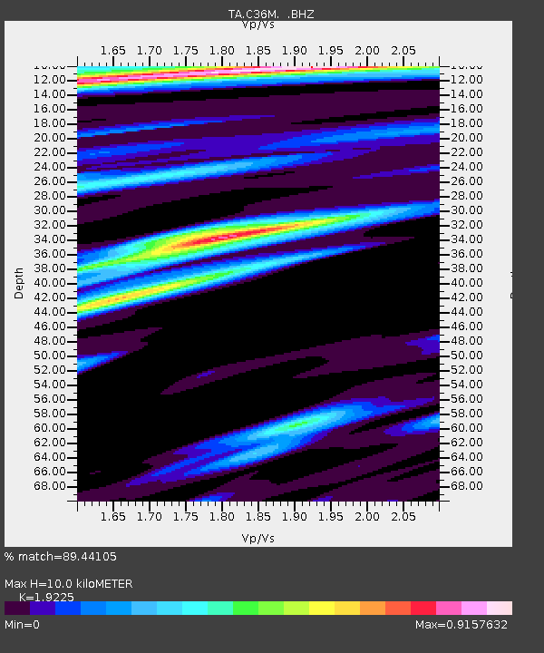
C36M Paulatuk, NT, CAN - Earthquake Result Viewer
| Earthquake location: |
Solomon Islands |
| Earthquake latitude/longitude: |
-6.7/155.1 |
| Earthquake time(UTC): |
2014/04/19 (109) 01:04:03 GMT |
| Earthquake Depth: |
24 km |
| Earthquake Magnitude: |
6.6 MWB, 6.9 MI, 7.0 MI |
| Earthquake Catalog/Contributor: |
NEIC PDE/NEIC COMCAT |
|
| Network: |
TA USArray Transportable Network (new EarthScope stations) |
| Station: |
C36M Paulatuk, NT, CAN |
| Lat/Lon: |
69.35 N/124.07 W |
| Elevation: |
10 m |
|
| Distance: |
93.0 deg |
| Az: |
20.532 deg |
| Baz: |
259.105 deg |
| Ray Param: |
0.041345168 |
| Estimated Moho Depth: |
10.0 km |
| Estimated Crust Vp/Vs: |
1.92 |
| Assumed Crust Vp: |
6.459 km/s |
| Estimated Crust Vs: |
3.36 km/s |
| Estimated Crust Poisson's Ratio: |
0.31 |
|
| Radial Match: |
89.44105 % |
| Radial Bump: |
371 |
| Transverse Match: |
82.67654 % |
| Transverse Bump: |
400 |
| SOD ConfigId: |
626651 |
| Insert Time: |
2014-05-03 01:27:52.291 +0000 |
| GWidth: |
2.5 |
| Max Bumps: |
400 |
| Tol: |
0.001 |
|

Signal To Noise
| Channel | StoN | STA | LTA |
| TA:C36M: :BHZ:20140419T01:16:42.87498Z | 12.180041 | 1.6155187E-6 | 1.3263656E-7 |
| TA:C36M: :BHN:20140419T01:16:42.87498Z | 2.309232 | 2.1596611E-7 | 9.352292E-8 |
| TA:C36M: :BHE:20140419T01:16:42.87498Z | 4.578495 | 4.3381613E-7 | 9.475082E-8 |
| Arrivals |
| Ps | 1.5 SECOND |
| PpPs | 4.4 SECOND |
| PsPs/PpSs | 5.9 SECOND |


