You are here: Home > Network List > TA - USArray Transportable Network (new EarthScope stations) Stations List
> Station O03E Paynes Creek, CA, USA > Earthquake Result Viewer
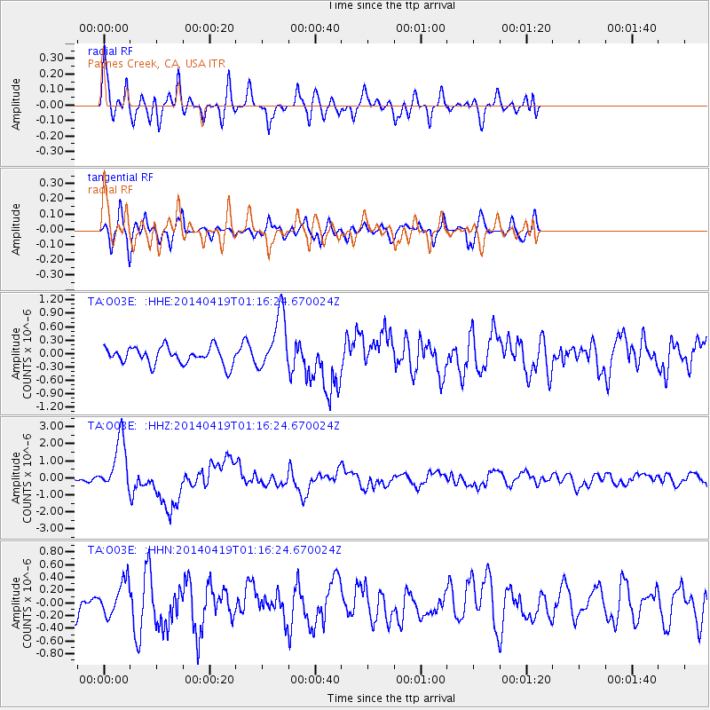
O03E Paynes Creek, CA, USA - Earthquake Result Viewer
*The percent match for this event was below the threshold and hence no stack was calculated.
| Earthquake location: |
Solomon Islands |
| Earthquake latitude/longitude: |
-6.7/155.1 |
| Earthquake time(UTC): |
2014/04/19 (109) 01:04:03 GMT |
| Earthquake Depth: |
24 km |
| Earthquake Magnitude: |
6.6 MWB, 6.9 MI, 7.0 MI |
| Earthquake Catalog/Contributor: |
NEIC PDE/NEIC COMCAT |
|
| Network: |
TA USArray Transportable Network (new EarthScope stations) |
| Station: |
O03E Paynes Creek, CA, USA |
| Lat/Lon: |
40.29 N/121.80 W |
| Elevation: |
967 m |
|
| Distance: |
89.0 deg |
| Az: |
49.416 deg |
| Baz: |
260.496 deg |
| Ray Param: |
$rayparam |
*The percent match for this event was below the threshold and hence was not used in the summary stack. |
|
| Radial Match: |
74.6358 % |
| Radial Bump: |
400 |
| Transverse Match: |
65.3149 % |
| Transverse Bump: |
394 |
| SOD ConfigId: |
626651 |
| Insert Time: |
2014-05-03 01:29:29.866 +0000 |
| GWidth: |
2.5 |
| Max Bumps: |
400 |
| Tol: |
0.001 |
|
Signal To Noise
| Channel | StoN | STA | LTA |
| TA:O03E: :HHZ:20140419T01:16:24.670024Z | 9.748855 | 1.5513398E-6 | 1.5913047E-7 |
| TA:O03E: :HHN:20140419T01:16:24.670024Z | 1.7168131 | 2.7079372E-7 | 1.5773047E-7 |
| TA:O03E: :HHE:20140419T01:16:24.670024Z | 3.3972862 | 6.4074237E-7 | 1.8860419E-7 |
| Arrivals |
| Ps | |
| PpPs | |
| PsPs/PpSs | |


