You are here: Home > Network List > US - United States National Seismic Network Stations List
> Station MSO Missoula, Montana, USA > Earthquake Result Viewer
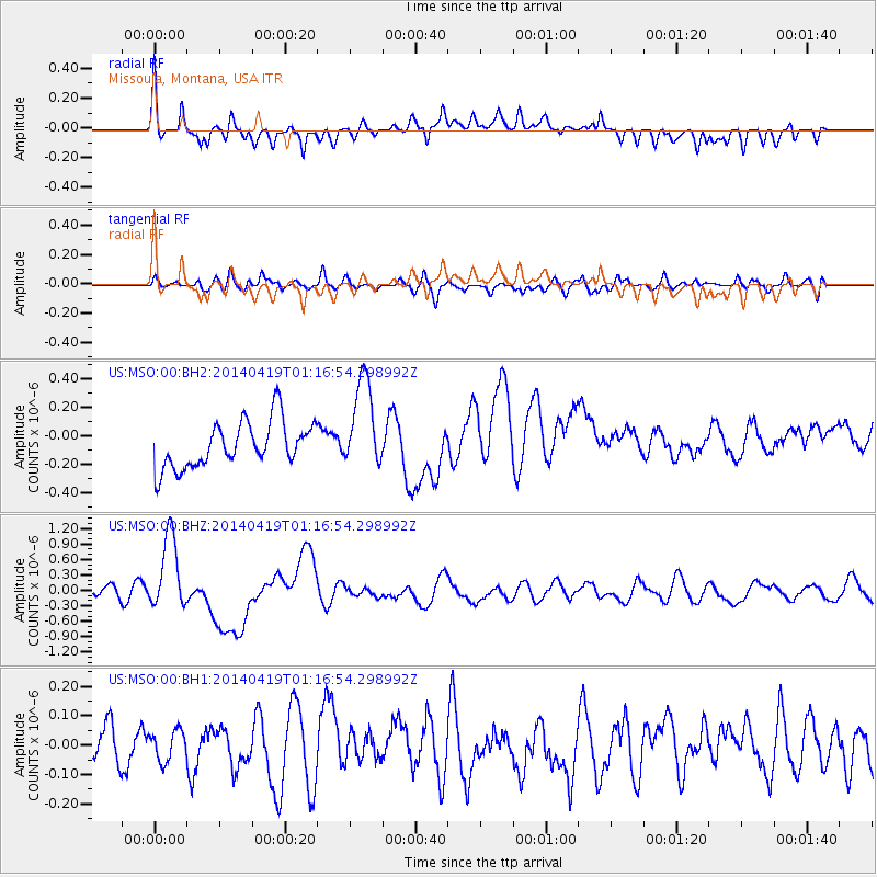
MSO Missoula, Montana, USA - Earthquake Result Viewer
*The percent match for this event was below the threshold and hence no stack was calculated.
| Earthquake location: |
Solomon Islands |
| Earthquake latitude/longitude: |
-6.7/155.1 |
| Earthquake time(UTC): |
2014/04/19 (109) 01:04:03 GMT |
| Earthquake Depth: |
24 km |
| Earthquake Magnitude: |
6.6 MWB, 6.9 MI, 7.0 MI |
| Earthquake Catalog/Contributor: |
NEIC PDE/NEIC COMCAT |
|
| Network: |
US United States National Seismic Network |
| Station: |
MSO Missoula, Montana, USA |
| Lat/Lon: |
46.83 N/113.94 W |
| Elevation: |
1264 m |
|
| Distance: |
95.5 deg |
| Az: |
43.604 deg |
| Baz: |
266.138 deg |
| Ray Param: |
$rayparam |
*The percent match for this event was below the threshold and hence was not used in the summary stack. |
|
| Radial Match: |
73.46242 % |
| Radial Bump: |
400 |
| Transverse Match: |
51.406403 % |
| Transverse Bump: |
400 |
| SOD ConfigId: |
626651 |
| Insert Time: |
2014-05-03 01:31:09.622 +0000 |
| GWidth: |
2.5 |
| Max Bumps: |
400 |
| Tol: |
0.001 |
|
Signal To Noise
| Channel | StoN | STA | LTA |
| US:MSO:00:BHZ:20140419T01:16:54.298992Z | 7.4908066 | 7.2455293E-7 | 9.672562E-8 |
| US:MSO:00:BH1:20140419T01:16:54.298992Z | 0.4625015 | 5.3162616E-8 | 1.1494583E-7 |
| US:MSO:00:BH2:20140419T01:16:54.298992Z | 1.999747 | 3.2214075E-7 | 1.6109074E-7 |
| Arrivals |
| Ps | |
| PpPs | |
| PsPs/PpSs | |


