You are here: Home > Network List > TA - USArray Transportable Network (new EarthScope stations) Stations List
> Station M59A Waymart, PA, USA > Earthquake Result Viewer
M59A Waymart, PA, USA - Earthquake Result Viewer
*The percent match for this event was below the threshold and hence no stack was calculated.
| Earthquake location: |
Northern Mid-Atlantic Ridge |
| Earthquake latitude/longitude: |
52.6/-32.0 |
| Earthquake time(UTC): |
2015/02/13 (044) 18:48:17 GMT |
| Earthquake Depth: |
12 km |
| Earthquake Magnitude: |
5.7 MW |
| Earthquake Catalog/Contributor: |
ISC/ISC |
|
| Network: |
TA USArray Transportable Network (new EarthScope stations) |
| Station: |
M59A Waymart, PA, USA |
| Lat/Lon: |
41.54 N/75.43 W |
| Elevation: |
471 m |
|
| Distance: |
31.1 deg |
| Az: |
266.746 deg |
| Baz: |
54.142 deg |
| Ray Param: |
$rayparam |
*The percent match for this event was below the threshold and hence was not used in the summary stack. |
|
| Radial Match: |
75.29117 % |
| Radial Bump: |
376 |
| Transverse Match: |
68.649506 % |
| Transverse Bump: |
400 |
| SOD ConfigId: |
7019011 |
| Insert Time: |
2019-04-16 19:08:01.660 +0000 |
| GWidth: |
2.5 |
| Max Bumps: |
400 |
| Tol: |
0.001 |
|
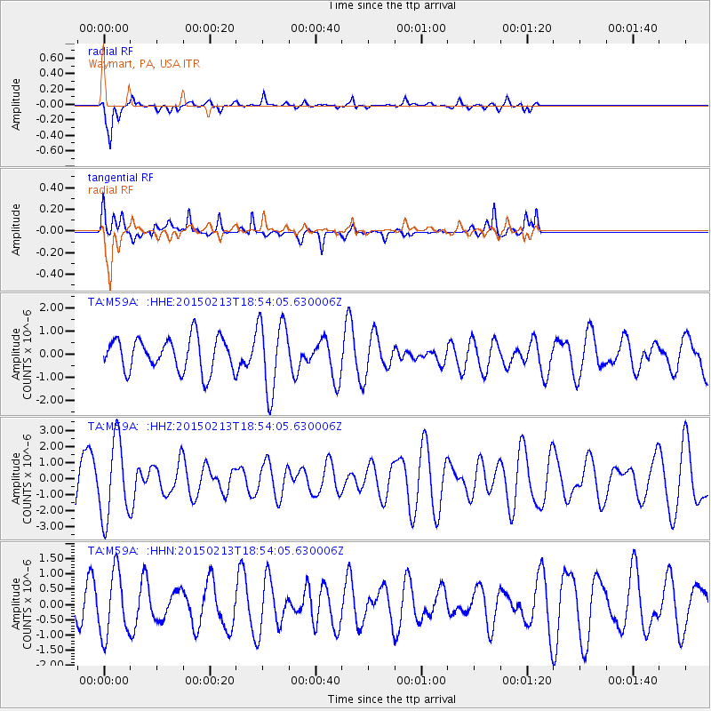
Signal To Noise
| Channel | StoN | STA | LTA |
| TA:M59A: :HHZ:20150213T18:54:05.630006Z | 1.5956231 | 2.4358374E-6 | 1.5265744E-6 |
| TA:M59A: :HHN:20150213T18:54:05.630006Z | 1.1822141 | 1.056314E-6 | 8.9350476E-7 |
| TA:M59A: :HHE:20150213T18:54:05.630006Z | 2.1837115 | 1.5506658E-6 | 7.101056E-7 |
| Arrivals |
| Ps | |
| PpPs | |
| PsPs/PpSs | |


