You are here: Home > Network List > AK - Alaska Regional Network Stations List
> Station DHY Denali Highway > Earthquake Result Viewer
DHY Denali Highway - Earthquake Result Viewer
| Earthquake location: |
Solomon Islands |
| Earthquake latitude/longitude: |
-6.7/154.9 |
| Earthquake time(UTC): |
2014/04/19 (109) 13:27:59 GMT |
| Earthquake Depth: |
31 km |
| Earthquake Magnitude: |
7.5 MWW, 7.8 MI |
| Earthquake Catalog/Contributor: |
NEIC PDE/NEIC COMCAT |
|
| Network: |
AK Alaska Regional Network |
| Station: |
DHY Denali Highway |
| Lat/Lon: |
63.08 N/147.38 W |
| Elevation: |
1609 m |
|
| Distance: |
82.1 deg |
| Az: |
22.861 deg |
| Baz: |
237.95 deg |
| Ray Param: |
0.047110166 |
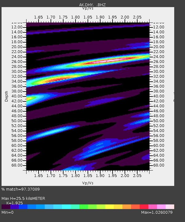
| Estimated Moho Depth: |
25.5 km |
| Estimated Crust Vp/Vs: |
1.92 |
| Assumed Crust Vp: |
6.566 km/s |
| Estimated Crust Vs: |
3.411 km/s |
| Estimated Crust Poisson's Ratio: |
0.32 |
|
| Radial Match: |
97.37089 % |
| Radial Bump: |
400 |
| Transverse Match: |
85.7439 % |
| Transverse Bump: |
400 |
| SOD ConfigId: |
626651 |
| Insert Time: |
2014-05-03 13:38:44.444 +0000 |
| GWidth: |
2.5 |
| Max Bumps: |
400 |
| Tol: |
0.001 |
|

Signal To Noise
| Channel | StoN | STA | LTA |
| AK:DHY: :BHZ:20140419T13:39:45.567993Z | 36.911633 | 1.03234315E-5 | 2.796796E-7 |
| AK:DHY: :BHN:20140419T13:39:45.567993Z | 11.974968 | 2.0062166E-6 | 1.675342E-7 |
| AK:DHY: :BHE:20140419T13:39:45.567993Z | 20.488514 | 3.4832606E-6 | 1.7001042E-7 |
| Arrivals |
| Ps | 3.7 SECOND |
| PpPs | 11 SECOND |
| PsPs/PpSs | 15 SECOND |


