You are here: Home > Network List > AK - Alaska Regional Network Stations List
> Station GRNC Granite Creek, AK, USA > Earthquake Result Viewer
GRNC Granite Creek, AK, USA - Earthquake Result Viewer
| Earthquake location: |
Solomon Islands |
| Earthquake latitude/longitude: |
-6.7/154.9 |
| Earthquake time(UTC): |
2014/04/19 (109) 13:27:59 GMT |
| Earthquake Depth: |
31 km |
| Earthquake Magnitude: |
7.5 MWW, 7.8 MI |
| Earthquake Catalog/Contributor: |
NEIC PDE/NEIC COMCAT |
|
| Network: |
AK Alaska Regional Network |
| Station: |
GRNC Granite Creek, AK, USA |
| Lat/Lon: |
60.73 N/141.76 W |
| Elevation: |
2116 m |
|
| Distance: |
83.2 deg |
| Az: |
26.241 deg |
| Baz: |
243.336 deg |
| Ray Param: |
0.046299517 |
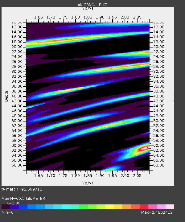
| Estimated Moho Depth: |
60.5 km |
| Estimated Crust Vp/Vs: |
2.09 |
| Assumed Crust Vp: |
6.566 km/s |
| Estimated Crust Vs: |
3.142 km/s |
| Estimated Crust Poisson's Ratio: |
0.35 |
|
| Radial Match: |
96.699715 % |
| Radial Bump: |
400 |
| Transverse Match: |
81.121704 % |
| Transverse Bump: |
400 |
| SOD ConfigId: |
626651 |
| Insert Time: |
2014-05-03 13:39:28.982 +0000 |
| GWidth: |
2.5 |
| Max Bumps: |
400 |
| Tol: |
0.001 |
|

Signal To Noise
| Channel | StoN | STA | LTA |
| AK:GRNC: :BHZ:20140419T13:39:51.607971Z | 17.001917 | 6.329742E-6 | 3.7229577E-7 |
| AK:GRNC: :BHN:20140419T13:39:51.607971Z | 8.715294 | 1.6166124E-6 | 1.8549143E-7 |
| AK:GRNC: :BHE:20140419T13:39:51.607971Z | 11.433435 | 1.7429852E-6 | 1.5244632E-7 |
| Arrivals |
| Ps | 10 SECOND |
| PpPs | 28 SECOND |
| PsPs/PpSs | 38 SECOND |


