You are here: Home > Network List > AK - Alaska Regional Network Stations List
> Station NICH Nichawak Mountain, AK, USA > Earthquake Result Viewer
NICH Nichawak Mountain, AK, USA - Earthquake Result Viewer
| Earthquake location: |
Solomon Islands |
| Earthquake latitude/longitude: |
-6.7/154.9 |
| Earthquake time(UTC): |
2014/04/19 (109) 13:27:59 GMT |
| Earthquake Depth: |
31 km |
| Earthquake Magnitude: |
7.5 MWW, 7.8 MI |
| Earthquake Catalog/Contributor: |
NEIC PDE/NEIC COMCAT |
|
| Network: |
AK Alaska Regional Network |
| Station: |
NICH Nichawak Mountain, AK, USA |
| Lat/Lon: |
60.24 N/143.97 W |
| Elevation: |
507 m |
|
| Distance: |
82.0 deg |
| Az: |
26.172 deg |
| Baz: |
241.404 deg |
| Ray Param: |
0.047134236 |
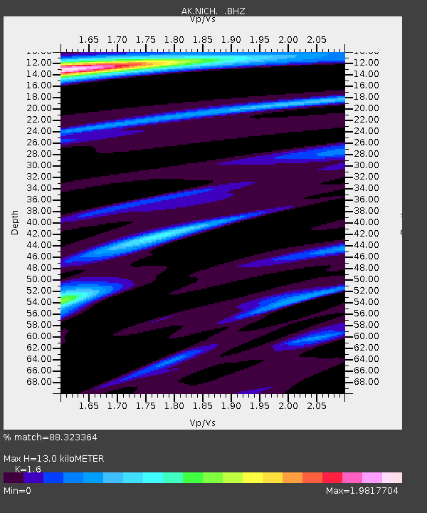
| Estimated Moho Depth: |
13.0 km |
| Estimated Crust Vp/Vs: |
1.60 |
| Assumed Crust Vp: |
6.566 km/s |
| Estimated Crust Vs: |
4.104 km/s |
| Estimated Crust Poisson's Ratio: |
0.18 |
|
| Radial Match: |
88.323364 % |
| Radial Bump: |
400 |
| Transverse Match: |
87.26821 % |
| Transverse Bump: |
400 |
| SOD ConfigId: |
626651 |
| Insert Time: |
2014-05-03 13:40:32.869 +0000 |
| GWidth: |
2.5 |
| Max Bumps: |
400 |
| Tol: |
0.001 |
|

Signal To Noise
| Channel | StoN | STA | LTA |
| AK:NICH: :BHZ:20140419T13:39:45.388Z | 19.817703 | 8.749364E-6 | 4.4149232E-7 |
| AK:NICH: :BHN:20140419T13:39:45.388Z | 1.9056858 | 8.9481114E-7 | 4.6954813E-7 |
| AK:NICH: :BHE:20140419T13:39:45.388Z | 3.715716 | 1.999112E-6 | 5.380153E-7 |
| Arrivals |
| Ps | 1.2 SECOND |
| PpPs | 5.0 SECOND |
| PsPs/PpSs | 6.2 SECOND |


