You are here: Home > Network List > AK - Alaska Regional Network Stations List
> Station NIKH Nikolski High Hill > Earthquake Result Viewer
NIKH Nikolski High Hill - Earthquake Result Viewer
| Earthquake location: |
Solomon Islands |
| Earthquake latitude/longitude: |
-6.7/154.9 |
| Earthquake time(UTC): |
2014/04/19 (109) 13:27:59 GMT |
| Earthquake Depth: |
31 km |
| Earthquake Magnitude: |
7.5 MWW, 7.8 MI |
| Earthquake Catalog/Contributor: |
NEIC PDE/NEIC COMCAT |
|
| Network: |
AK Alaska Regional Network |
| Station: |
NIKH Nikolski High Hill |
| Lat/Lon: |
52.97 N/168.85 W |
| Elevation: |
199 m |
|
| Distance: |
66.9 deg |
| Az: |
22.855 deg |
| Baz: |
219.634 deg |
| Ray Param: |
0.057249054 |
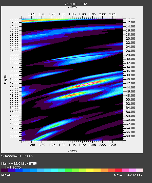
| Estimated Moho Depth: |
42.0 km |
| Estimated Crust Vp/Vs: |
1.93 |
| Assumed Crust Vp: |
5.88 km/s |
| Estimated Crust Vs: |
3.051 km/s |
| Estimated Crust Poisson's Ratio: |
0.32 |
|
| Radial Match: |
91.86446 % |
| Radial Bump: |
400 |
| Transverse Match: |
83.22194 % |
| Transverse Bump: |
400 |
| SOD ConfigId: |
626651 |
| Insert Time: |
2014-05-03 13:40:37.497 +0000 |
| GWidth: |
2.5 |
| Max Bumps: |
400 |
| Tol: |
0.001 |
|

Signal To Noise
| Channel | StoN | STA | LTA |
| AK:NIKH: :BHZ:20140419T13:38:17.90802Z | 25.350002 | 1.5436666E-5 | 6.089414E-7 |
| AK:NIKH: :BHN:20140419T13:38:17.90802Z | 6.2142696 | 5.589798E-6 | 8.9951004E-7 |
| AK:NIKH: :BHE:20140419T13:38:17.90802Z | 5.178737 | 4.030189E-6 | 7.7821846E-7 |
| Arrivals |
| Ps | 6.8 SECOND |
| PpPs | 20 SECOND |
| PsPs/PpSs | 27 SECOND |


