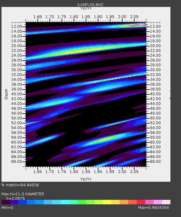
KAPI Kappang, Sulawesi, Indonesia - Earthquake Result Viewer
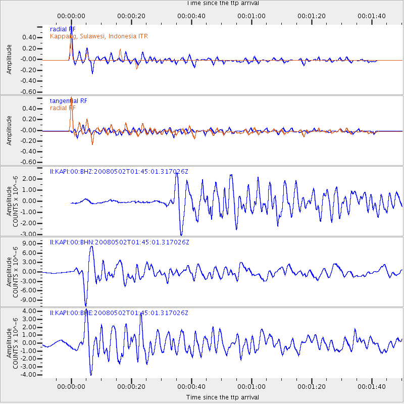
Earthquake location: Andreanof Islands, Aleutian Is.
Earthquake latitude/longitude: 51.9/-177.5
Earthquake time(UTC): 2008/05/02 (123) 01:33:37 GMT
Earthquake Depth: 14 km
Earthquake Magnitude: 6.3 MB, 6.8 MS, 6.6 MW, 6.6 MW
Earthquake Catalog/Contributor: WHDF/NEIC
Network: II Global Seismograph Network (GSN - IRIS/IDA)
Station: KAPI Kappang, Sulawesi, Indonesia
Lat/Lon: 5.01 S/119.75 E
Elevation: 300 m
Distance: 77.6 deg
Az: 245.044 deg
Baz: 34.356 deg
Ray Param: 0.05021636
Estimated Moho Depth: 11.0 km
Estimated Crust Vp/Vs: 2.10
Assumed Crust Vp: 6.343 km/s
Estimated Crust Vs: 3.024 km/s
Estimated Crust Poisson's Ratio: 0.35
Radial Match: 94.64836 %
Radial Bump: 316
Transverse Match: 85.62383 %
Transverse Bump: 400
SOD ConfigId: 2504
Insert Time: 2010-03-01 21:20:15.439 +0000
GWidth: 2.5
Max Bumps: 400
Tol: 0.001

Signal To Noise

ChannelStoNSTALTA
II:KAPI:00:BHN:20080502T01:45:01.317026Z24.8834483.1636503E-61.2713875E-7
II:KAPI:00:BHE:20080502T01:45:01.317026Z4.92007641.1236964E-62.2839004E-7
II:KAPI:00:BHZ:20080502T01:45:01.317026Z5.66984565.799435E-71.0228559E-7
Arrivals
Ps2.0 SECOND
PpPs5.2 SECOND
PsPs/PpSs7.2 SECOND