You are here: Home > Network List > GS - US Geological Survey Networks Stations List
> Station OK031 2598 S. Brethren Rd., Cushing, OK, USA > Earthquake Result Viewer
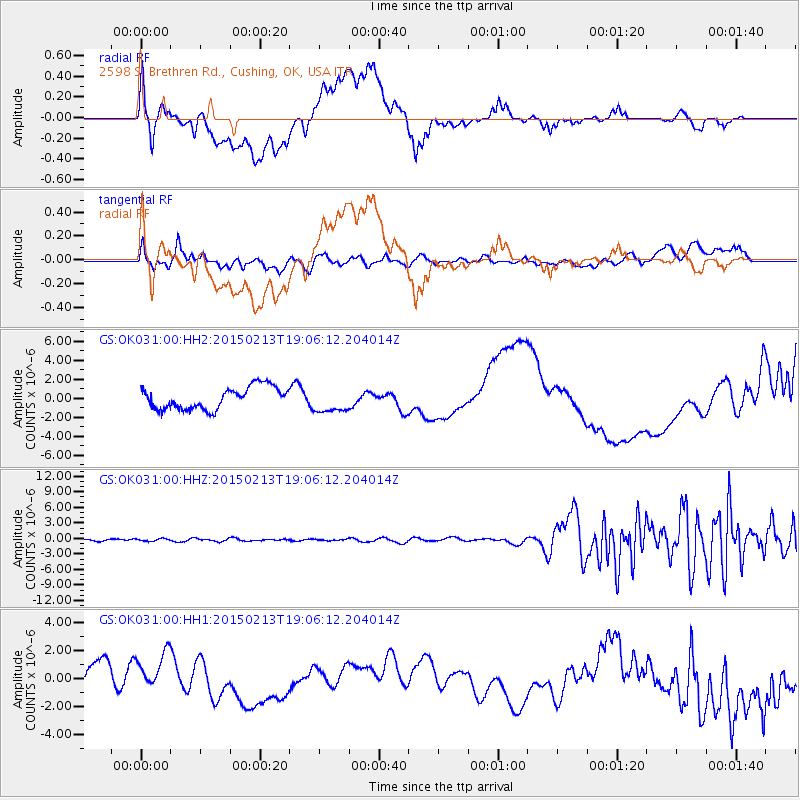
OK031 2598 S. Brethren Rd., Cushing, OK, USA - Earthquake Result Viewer
*The percent match for this event was below the threshold and hence no stack was calculated.
| Earthquake location: |
Northern Mid-Atlantic Ridge |
| Earthquake latitude/longitude: |
52.5/-31.7 |
| Earthquake time(UTC): |
2015/02/13 (044) 18:58:05 GMT |
| Earthquake Depth: |
12 km |
| Earthquake Magnitude: |
4.9 mb |
| Earthquake Catalog/Contributor: |
ISC/ISC |
|
| Network: |
GS US Geological Survey Networks |
| Station: |
OK031 2598 S. Brethren Rd., Cushing, OK, USA |
| Lat/Lon: |
35.95 N/96.84 W |
| Elevation: |
290 m |
|
| Distance: |
47.9 deg |
| Az: |
276.754 deg |
| Baz: |
48.391 deg |
| Ray Param: |
$rayparam |
*The percent match for this event was below the threshold and hence was not used in the summary stack. |
|
| Radial Match: |
40.513184 % |
| Radial Bump: |
400 |
| Transverse Match: |
23.944344 % |
| Transverse Bump: |
400 |
| SOD ConfigId: |
7019011 |
| Insert Time: |
2019-04-16 19:14:29.489 +0000 |
| GWidth: |
2.5 |
| Max Bumps: |
400 |
| Tol: |
0.001 |
|
Signal To Noise
| Channel | StoN | STA | LTA |
| GS:OK031:00:HHZ:20150213T19:06:12.204014Z | 0.57450306 | 2.2908921E-7 | 3.9876065E-7 |
| GS:OK031:00:HH1:20150213T19:06:12.204014Z | 0.9987214 | 1.536635E-6 | 1.5386021E-6 |
| GS:OK031:00:HH2:20150213T19:06:12.204014Z | 1.108994 | 1.2901712E-6 | 1.1633707E-6 |
| Arrivals |
| Ps | |
| PpPs | |
| PsPs/PpSs | |


