You are here: Home > Network List > AZ - ANZA Regional Network Stations List
> Station SMER AZ.SMER > Earthquake Result Viewer
SMER AZ.SMER - Earthquake Result Viewer
| Earthquake location: |
Solomon Islands |
| Earthquake latitude/longitude: |
-6.7/154.9 |
| Earthquake time(UTC): |
2014/04/19 (109) 13:27:59 GMT |
| Earthquake Depth: |
31 km |
| Earthquake Magnitude: |
7.5 MWW, 7.8 MI |
| Earthquake Catalog/Contributor: |
NEIC PDE/NEIC COMCAT |
|
| Network: |
AZ ANZA Regional Network |
| Station: |
SMER AZ.SMER |
| Lat/Lon: |
33.46 N/117.17 W |
| Elevation: |
355 m |
|
| Distance: |
91.9 deg |
| Az: |
56.709 deg |
| Baz: |
263.267 deg |
| Ray Param: |
0.041530583 |
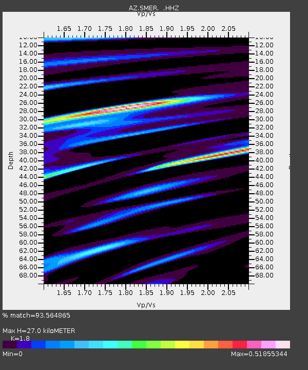
| Estimated Moho Depth: |
27.0 km |
| Estimated Crust Vp/Vs: |
1.80 |
| Assumed Crust Vp: |
6.264 km/s |
| Estimated Crust Vs: |
3.48 km/s |
| Estimated Crust Poisson's Ratio: |
0.28 |
|
| Radial Match: |
93.564865 % |
| Radial Bump: |
380 |
| Transverse Match: |
89.26963 % |
| Transverse Bump: |
400 |
| SOD ConfigId: |
626651 |
| Insert Time: |
2014-05-03 13:46:44.348 +0000 |
| GWidth: |
2.5 |
| Max Bumps: |
400 |
| Tol: |
0.001 |
|
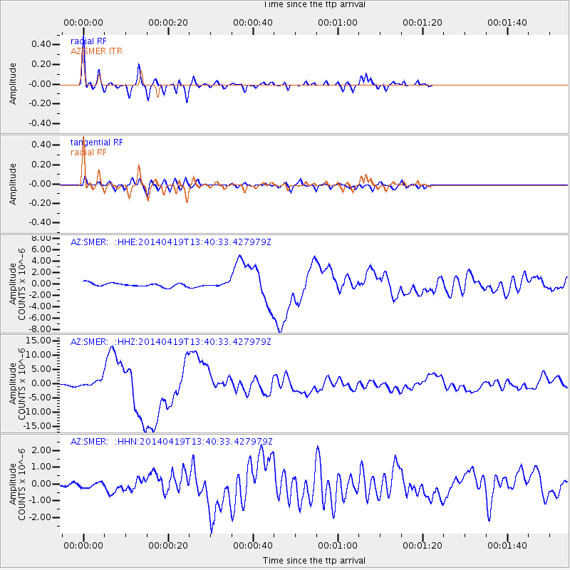
Signal To Noise
| Channel | StoN | STA | LTA |
| AZ:SMER: :HHZ:20140419T13:40:33.427979Z | 4.1937537 | 1.4443866E-6 | 3.4441382E-7 |
| AZ:SMER: :HHN:20140419T13:40:33.427979Z | 0.85722184 | 1.5352417E-7 | 1.7909503E-7 |
| AZ:SMER: :HHE:20140419T13:40:33.427979Z | 0.9987918 | 3.1605856E-7 | 3.164409E-7 |
| Arrivals |
| Ps | 3.5 SECOND |
| PpPs | 12 SECOND |
| PsPs/PpSs | 15 SECOND |


