You are here: Home > Network List > BK - Berkeley Digital Seismograph Network Stations List
> Station HUMO Hull Mountain, OR > Earthquake Result Viewer
HUMO Hull Mountain, OR - Earthquake Result Viewer

| Earthquake location: |
Solomon Islands |
| Earthquake latitude/longitude: |
-6.7/154.9 |
| Earthquake time(UTC): |
2014/04/19 (109) 13:27:59 GMT |
| Earthquake Depth: |
31 km |
| Earthquake Magnitude: |
7.5 MWW, 7.8 MI |
| Earthquake Catalog/Contributor: |
NEIC PDE/NEIC COMCAT |
|
| Network: |
BK Berkeley Digital Seismograph Network |
| Station: |
HUMO Hull Mountain, OR |
| Lat/Lon: |
42.61 N/122.96 W |
| Elevation: |
555 m |
|
| Distance: |
88.7 deg |
| Az: |
47.01 deg |
| Baz: |
259.758 deg |
| Ray Param: |
0.042333122 |
| Estimated Moho Depth: |
22.25 km |
| Estimated Crust Vp/Vs: |
2.06 |
| Assumed Crust Vp: |
6.522 km/s |
| Estimated Crust Vs: |
3.17 km/s |
| Estimated Crust Poisson's Ratio: |
0.35 |
|
| Radial Match: |
97.946785 % |
| Radial Bump: |
372 |
| Transverse Match: |
81.74076 % |
| Transverse Bump: |
400 |
| SOD ConfigId: |
626651 |
| Insert Time: |
2014-05-03 13:47:16.432 +0000 |
| GWidth: |
2.5 |
| Max Bumps: |
400 |
| Tol: |
0.001 |
|
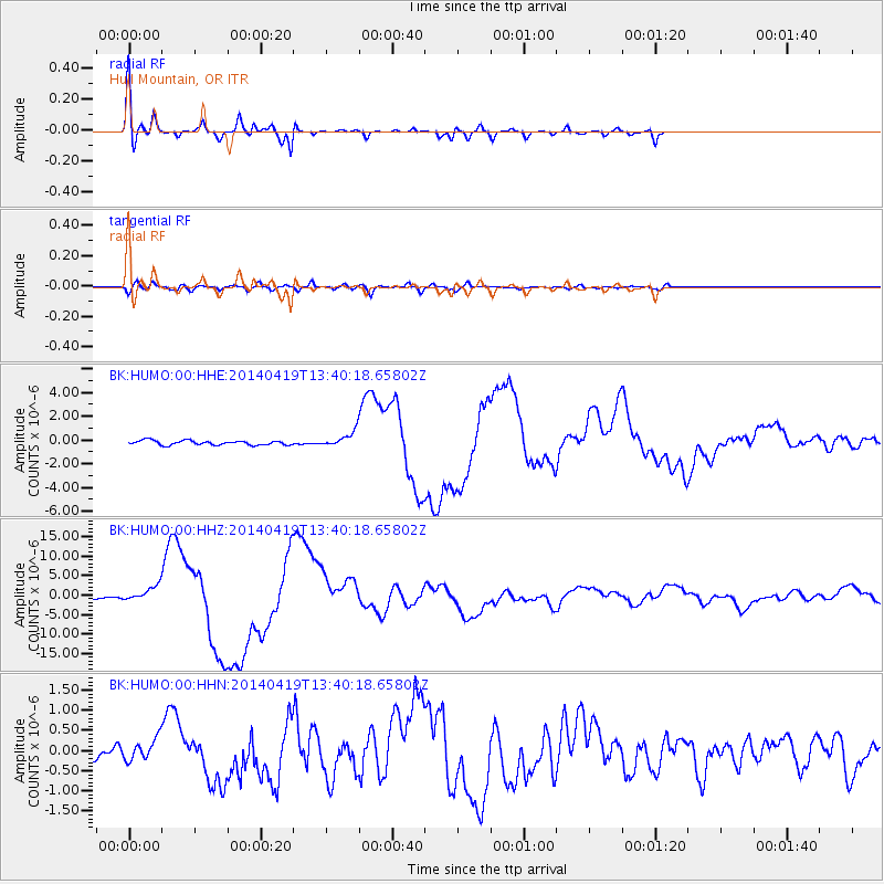
Signal To Noise
| Channel | StoN | STA | LTA |
| BK:HUMO:00:HHZ:20140419T13:40:18.65802Z | 7.326577 | 1.9335046E-6 | 2.6390285E-7 |
| BK:HUMO:00:HHN:20140419T13:40:18.65802Z | 1.7781848 | 2.6769393E-7 | 1.5054337E-7 |
| BK:HUMO:00:HHE:20140419T13:40:18.65802Z | 3.1962664 | 6.033209E-7 | 1.8875802E-7 |
| Arrivals |
| Ps | 3.7 SECOND |
| PpPs | 10 SECOND |
| PsPs/PpSs | 14 SECOND |


