You are here: Home > Network List > TA - USArray Transportable Network (new EarthScope stations) Stations List
> Station J57A Williamstown, NY, USA > Earthquake Result Viewer
J57A Williamstown, NY, USA - Earthquake Result Viewer
| Earthquake location: |
Northern Mid-Atlantic Ridge |
| Earthquake latitude/longitude: |
52.5/-31.7 |
| Earthquake time(UTC): |
2015/02/13 (044) 18:58:05 GMT |
| Earthquake Depth: |
12 km |
| Earthquake Magnitude: |
4.9 mb |
| Earthquake Catalog/Contributor: |
ISC/ISC |
|
| Network: |
TA USArray Transportable Network (new EarthScope stations) |
| Station: |
J57A Williamstown, NY, USA |
| Lat/Lon: |
43.41 N/76.00 W |
| Elevation: |
191 m |
|
| Distance: |
30.6 deg |
| Az: |
270.617 deg |
| Baz: |
56.953 deg |
| Ray Param: |
0.07928566 |
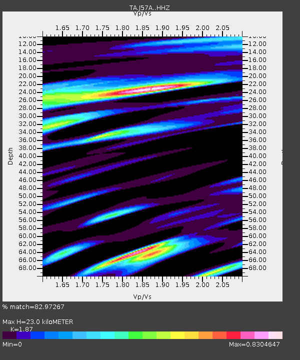
| Estimated Moho Depth: |
23.0 km |
| Estimated Crust Vp/Vs: |
1.87 |
| Assumed Crust Vp: |
6.419 km/s |
| Estimated Crust Vs: |
3.433 km/s |
| Estimated Crust Poisson's Ratio: |
0.30 |
|
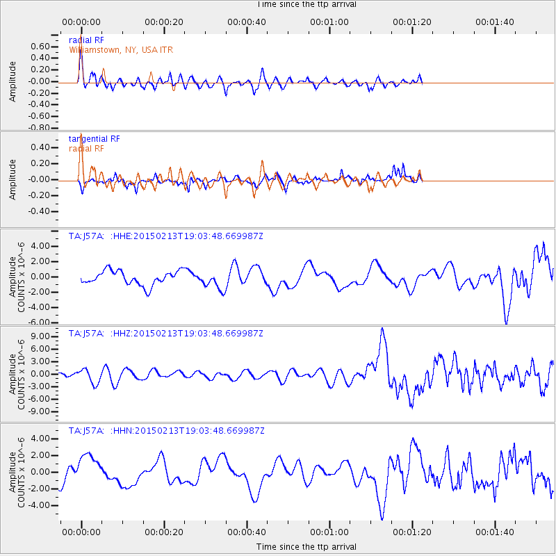
| Radial Match: |
82.97267 % |
| Radial Bump: |
400 |
| Transverse Match: |
48.575962 % |
| Transverse Bump: |
264 |
| SOD ConfigId: |
7019011 |
| Insert Time: |
2019-04-16 19:17:52.347 +0000 |
| GWidth: |
2.5 |
| Max Bumps: |
400 |
| Tol: |
0.001 |
|
Signal To Noise
| Channel | StoN | STA | LTA |
| TA:J57A: :HHZ:20150213T19:03:48.669987Z | 1.8369622 | 1.7632926E-6 | 9.598959E-7 |
| TA:J57A: :HHN:20150213T19:03:48.669987Z | 1.7395816 | 1.918572E-6 | 1.1028928E-6 |
| TA:J57A: :HHE:20150213T19:03:48.669987Z | 1.296809 | 1.1970767E-6 | 9.230941E-7 |
| Arrivals |
| Ps | 3.4 SECOND |
| PpPs | 9.5 SECOND |
| PsPs/PpSs | 13 SECOND |


