You are here: Home > Network List > TA - USArray Transportable Network (new EarthScope stations) Stations List
> Station U54A Nelson's Funny Farm, Mountain City, TN, USA > Earthquake Result Viewer
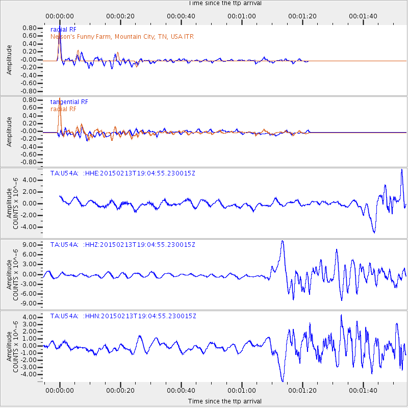
U54A Nelson's Funny Farm, Mountain City, TN, USA - Earthquake Result Viewer
| Earthquake location: |
Northern Mid-Atlantic Ridge |
| Earthquake latitude/longitude: |
52.5/-31.7 |
| Earthquake time(UTC): |
2015/02/13 (044) 18:58:05 GMT |
| Earthquake Depth: |
12 km |
| Earthquake Magnitude: |
4.9 mb |
| Earthquake Catalog/Contributor: |
ISC/ISC |
|
| Network: |
TA USArray Transportable Network (new EarthScope stations) |
| Station: |
U54A Nelson's Funny Farm, Mountain City, TN, USA |
| Lat/Lon: |
36.52 N/81.82 W |
| Elevation: |
837 m |
|
| Distance: |
38.3 deg |
| Az: |
265.671 deg |
| Baz: |
49.13 deg |
| Ray Param: |
0.07562361 |
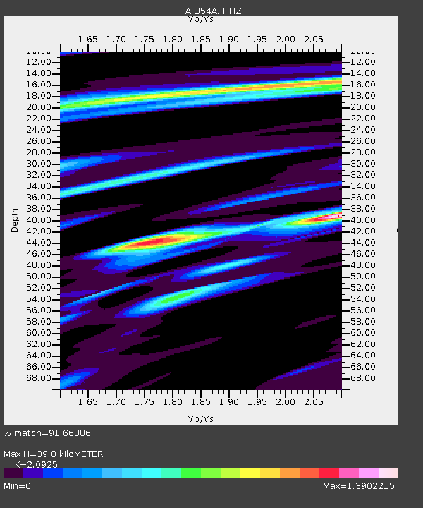
| Estimated Moho Depth: |
39.0 km |
| Estimated Crust Vp/Vs: |
2.09 |
| Assumed Crust Vp: |
6.159 km/s |
| Estimated Crust Vs: |
2.943 km/s |
| Estimated Crust Poisson's Ratio: |
0.35 |
|
| Radial Match: |
91.66386 % |
| Radial Bump: |
355 |
| Transverse Match: |
60.061497 % |
| Transverse Bump: |
400 |
| SOD ConfigId: |
7019011 |
| Insert Time: |
2019-04-16 19:18:10.595 +0000 |
| GWidth: |
2.5 |
| Max Bumps: |
400 |
| Tol: |
0.001 |
|
Signal To Noise
| Channel | StoN | STA | LTA |
| TA:U54A: :HHZ:20150213T19:04:55.230015Z | 0.8013654 | 4.2552804E-7 | 5.3100376E-7 |
| TA:U54A: :HHN:20150213T19:04:55.230015Z | 1.1067362 | 4.5919225E-7 | 4.149067E-7 |
| TA:U54A: :HHE:20150213T19:04:55.230015Z | 1.0006028 | 5.197799E-7 | 5.1946677E-7 |
| Arrivals |
| Ps | 7.3 SECOND |
| PpPs | 19 SECOND |
| PsPs/PpSs | 26 SECOND |


