You are here: Home > Network List > CN - Canadian National Seismograph Network Stations List
> Station INK INUVIK, NT > Earthquake Result Viewer
INK INUVIK, NT - Earthquake Result Viewer
| Earthquake location: |
Solomon Islands |
| Earthquake latitude/longitude: |
-6.7/154.9 |
| Earthquake time(UTC): |
2014/04/19 (109) 13:27:59 GMT |
| Earthquake Depth: |
31 km |
| Earthquake Magnitude: |
7.5 MWW, 7.8 MI |
| Earthquake Catalog/Contributor: |
NEIC PDE/NEIC COMCAT |
|
| Network: |
CN Canadian National Seismograph Network |
| Station: |
INK INUVIK, NT |
| Lat/Lon: |
68.31 N/133.53 W |
| Elevation: |
44 m |
|
| Distance: |
89.5 deg |
| Az: |
20.651 deg |
| Baz: |
250.419 deg |
| Ray Param: |
0.041779112 |
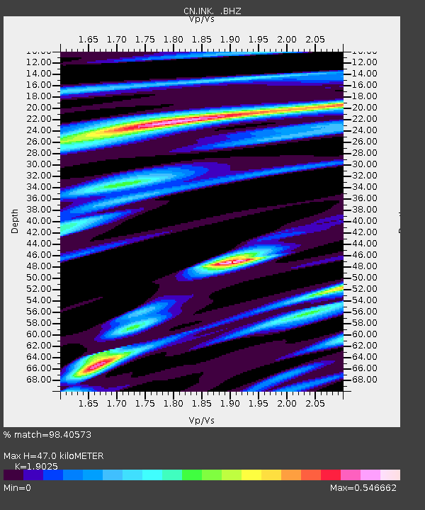
| Estimated Moho Depth: |
47.0 km |
| Estimated Crust Vp/Vs: |
1.90 |
| Assumed Crust Vp: |
6.171 km/s |
| Estimated Crust Vs: |
3.244 km/s |
| Estimated Crust Poisson's Ratio: |
0.31 |
|
| Radial Match: |
98.40573 % |
| Radial Bump: |
383 |
| Transverse Match: |
90.514145 % |
| Transverse Bump: |
400 |
| SOD ConfigId: |
626651 |
| Insert Time: |
2014-05-03 13:49:40.725 +0000 |
| GWidth: |
2.5 |
| Max Bumps: |
400 |
| Tol: |
0.001 |
|

Signal To Noise
| Channel | StoN | STA | LTA |
| CN:INK: :BHZ:20140419T13:40:22.224976Z | 63.09889 | 8.275558E-6 | 1.3115219E-7 |
| CN:INK: :BHN:20140419T13:40:22.224976Z | 14.819892 | 1.0719716E-6 | 7.233329E-8 |
| CN:INK: :BHE:20140419T13:40:22.224976Z | 28.237856 | 2.4770789E-6 | 8.7721915E-8 |
| Arrivals |
| Ps | 7.0 SECOND |
| PpPs | 22 SECOND |
| PsPs/PpSs | 29 SECOND |


