You are here: Home > Network List > G - GEOSCOPE Stations List
> Station CRZF Port Alfred, Crozet, South Indian Ocean > Earthquake Result Viewer
CRZF Port Alfred, Crozet, South Indian Ocean - Earthquake Result Viewer
| Earthquake location: |
Solomon Islands |
| Earthquake latitude/longitude: |
-6.7/154.9 |
| Earthquake time(UTC): |
2014/04/19 (109) 13:27:59 GMT |
| Earthquake Depth: |
31 km |
| Earthquake Magnitude: |
7.5 MWW, 7.8 MI |
| Earthquake Catalog/Contributor: |
NEIC PDE/NEIC COMCAT |
|
| Network: |
G GEOSCOPE |
| Station: |
CRZF Port Alfred, Crozet, South Indian Ocean |
| Lat/Lon: |
46.43 S/51.86 E |
| Elevation: |
140 m |
|
| Distance: |
94.1 deg |
| Az: |
222.491 deg |
| Baz: |
104.078 deg |
| Ray Param: |
0.0411123 |
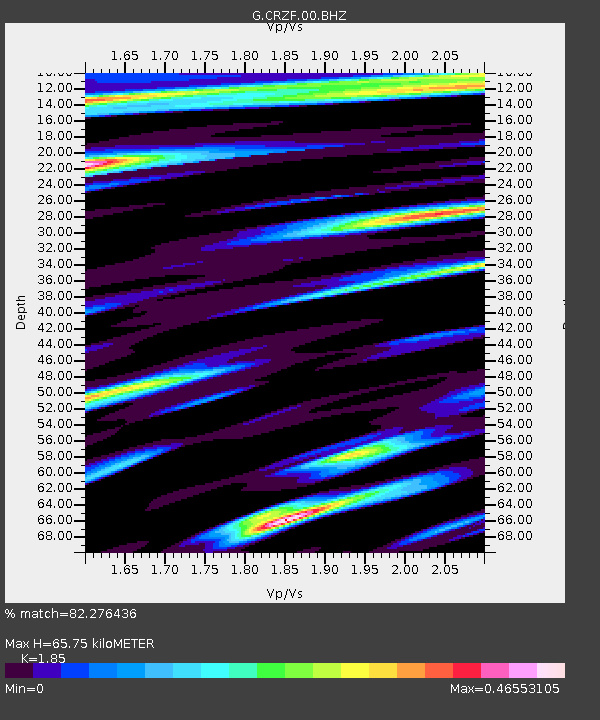
| Estimated Moho Depth: |
65.75 km |
| Estimated Crust Vp/Vs: |
1.85 |
| Assumed Crust Vp: |
4.802 km/s |
| Estimated Crust Vs: |
2.596 km/s |
| Estimated Crust Poisson's Ratio: |
0.29 |
|
| Radial Match: |
82.276436 % |
| Radial Bump: |
400 |
| Transverse Match: |
61.636173 % |
| Transverse Bump: |
400 |
| SOD ConfigId: |
626651 |
| Insert Time: |
2014-05-03 13:50:39.777 +0000 |
| GWidth: |
2.5 |
| Max Bumps: |
400 |
| Tol: |
0.001 |
|
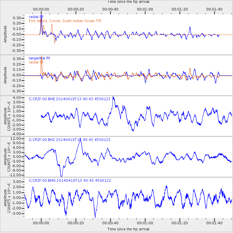
Signal To Noise
| Channel | StoN | STA | LTA |
| G:CRZF:00:BHZ:20140419T13:40:43.450012Z | 2.8355293 | 2.3516836E-6 | 8.2936316E-7 |
| G:CRZF:00:BHN:20140419T13:40:43.450012Z | 1.1514953 | 1.099261E-6 | 9.546379E-7 |
| G:CRZF:00:BHE:20140419T13:40:43.450012Z | 1.1955839 | 8.5526096E-7 | 7.1535E-7 |
| Arrivals |
| Ps | 12 SECOND |
| PpPs | 39 SECOND |
| PsPs/PpSs | 50 SECOND |


