You are here: Home > Network List > UU - University of Utah Regional Network Stations List
> Station BGU Big Grassy Mountain, UT, USA > Earthquake Result Viewer
BGU Big Grassy Mountain, UT, USA - Earthquake Result Viewer
| Earthquake location: |
Northern Mid-Atlantic Ridge |
| Earthquake latitude/longitude: |
52.5/-31.7 |
| Earthquake time(UTC): |
2015/02/13 (044) 18:58:05 GMT |
| Earthquake Depth: |
12 km |
| Earthquake Magnitude: |
4.9 mb |
| Earthquake Catalog/Contributor: |
ISC/ISC |
|
| Network: |
UU University of Utah Regional Network |
| Station: |
BGU Big Grassy Mountain, UT, USA |
| Lat/Lon: |
40.92 N/113.03 W |
| Elevation: |
1640 m |
|
| Distance: |
54.1 deg |
| Az: |
292.371 deg |
| Baz: |
48.201 deg |
| Ray Param: |
0.06564891 |
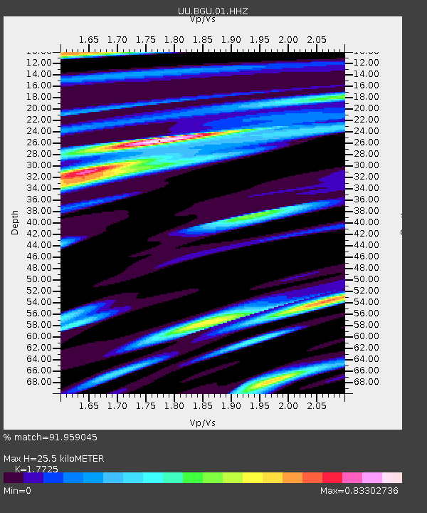
| Estimated Moho Depth: |
25.5 km |
| Estimated Crust Vp/Vs: |
1.77 |
| Assumed Crust Vp: |
6.276 km/s |
| Estimated Crust Vs: |
3.541 km/s |
| Estimated Crust Poisson's Ratio: |
0.27 |
|
| Radial Match: |
91.959045 % |
| Radial Bump: |
400 |
| Transverse Match: |
83.988884 % |
| Transverse Bump: |
369 |
| SOD ConfigId: |
7019011 |
| Insert Time: |
2019-04-16 19:18:42.787 +0000 |
| GWidth: |
2.5 |
| Max Bumps: |
400 |
| Tol: |
0.001 |
|

Signal To Noise
| Channel | StoN | STA | LTA |
| UU:BGU:01:HHZ:20150213T19:06:59.188022Z | 1.0396329 | 8.002161E-9 | 7.6971025E-9 |
| UU:BGU:01:HHN:20150213T19:06:59.188022Z | 0.53144526 | 4.5482653E-9 | 8.558295E-9 |
| UU:BGU:01:HHE:20150213T19:06:59.188022Z | 2.556874 | 1.4747347E-8 | 5.7677254E-9 |
| Arrivals |
| Ps | 3.3 SECOND |
| PpPs | 11 SECOND |
| PsPs/PpSs | 14 SECOND |


