You are here: Home > Network List > G - GEOSCOPE Stations List
> Station PAF Port aux Francais, Kerguelen (South Indian Ocean) > Earthquake Result Viewer
PAF Port aux Francais, Kerguelen (South Indian Ocean) - Earthquake Result Viewer
| Earthquake location: |
Solomon Islands |
| Earthquake latitude/longitude: |
-6.7/154.9 |
| Earthquake time(UTC): |
2014/04/19 (109) 13:27:59 GMT |
| Earthquake Depth: |
31 km |
| Earthquake Magnitude: |
7.5 MWW, 7.8 MI |
| Earthquake Catalog/Contributor: |
NEIC PDE/NEIC COMCAT |
|
| Network: |
G GEOSCOPE |
| Station: |
PAF Port aux Francais, Kerguelen (South Indian Ocean) |
| Lat/Lon: |
49.35 S/70.21 E |
| Elevation: |
17 m |
|
| Distance: |
81.5 deg |
| Az: |
221.177 deg |
| Baz: |
90.397 deg |
| Ray Param: |
0.047499266 |
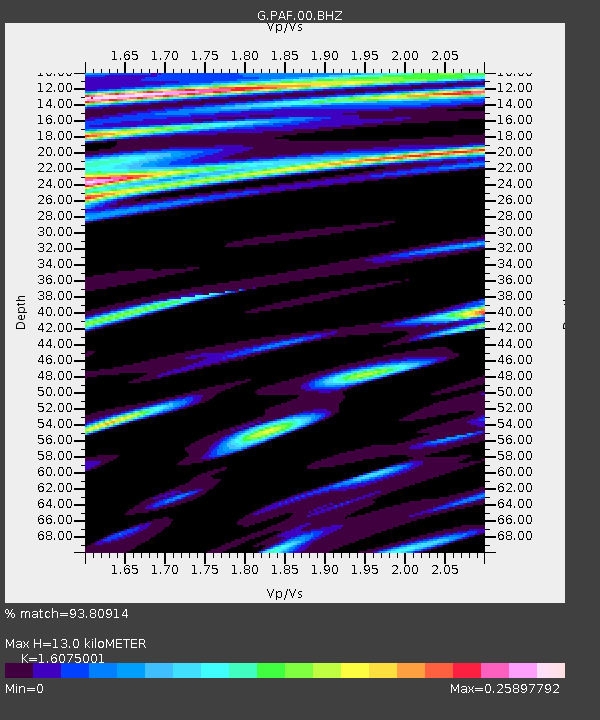
| Estimated Moho Depth: |
13.0 km |
| Estimated Crust Vp/Vs: |
1.61 |
| Assumed Crust Vp: |
4.73 km/s |
| Estimated Crust Vs: |
2.942 km/s |
| Estimated Crust Poisson's Ratio: |
0.18 |
|
| Radial Match: |
93.80914 % |
| Radial Bump: |
326 |
| Transverse Match: |
76.2163 % |
| Transverse Bump: |
400 |
| SOD ConfigId: |
626651 |
| Insert Time: |
2014-05-03 13:50:47.303 +0000 |
| GWidth: |
2.5 |
| Max Bumps: |
400 |
| Tol: |
0.001 |
|

Signal To Noise
| Channel | StoN | STA | LTA |
| G:PAF:00:BHZ:20140419T13:39:42.698975Z | 1.7080367 | 3.7507525E-6 | 2.1959438E-6 |
| G:PAF:00:BHN:20140419T13:39:42.698975Z | 0.5889253 | 8.7162164E-7 | 1.4800206E-6 |
| G:PAF:00:BHE:20140419T13:39:42.698975Z | 1.3333455 | 1.612068E-6 | 1.2090399E-6 |
| Arrivals |
| Ps | 1.7 SECOND |
| PpPs | 7.1 SECOND |
| PsPs/PpSs | 8.7 SECOND |


