You are here: Home > Network List > UU - University of Utah Regional Network Stations List
> Station CCUT Cedar City, UT, USA > Earthquake Result Viewer
CCUT Cedar City, UT, USA - Earthquake Result Viewer

| Earthquake location: |
Northern Mid-Atlantic Ridge |
| Earthquake latitude/longitude: |
52.5/-31.7 |
| Earthquake time(UTC): |
2015/02/13 (044) 18:58:05 GMT |
| Earthquake Depth: |
12 km |
| Earthquake Magnitude: |
4.9 mb |
| Earthquake Catalog/Contributor: |
ISC/ISC |
|
| Network: |
UU University of Utah Regional Network |
| Station: |
CCUT Cedar City, UT, USA |
| Lat/Lon: |
37.55 N/113.36 W |
| Elevation: |
2127 m |
|
| Distance: |
56.6 deg |
| Az: |
289.577 deg |
| Baz: |
46.402 deg |
| Ray Param: |
0.064043604 |
| Estimated Moho Depth: |
41.5 km |
| Estimated Crust Vp/Vs: |
1.68 |
| Assumed Crust Vp: |
6.194 km/s |
| Estimated Crust Vs: |
3.693 km/s |
| Estimated Crust Poisson's Ratio: |
0.22 |
|
| Radial Match: |
88.46867 % |
| Radial Bump: |
400 |
| Transverse Match: |
68.260284 % |
| Transverse Bump: |
400 |
| SOD ConfigId: |
7019011 |
| Insert Time: |
2019-04-16 19:18:44.543 +0000 |
| GWidth: |
2.5 |
| Max Bumps: |
400 |
| Tol: |
0.001 |
|
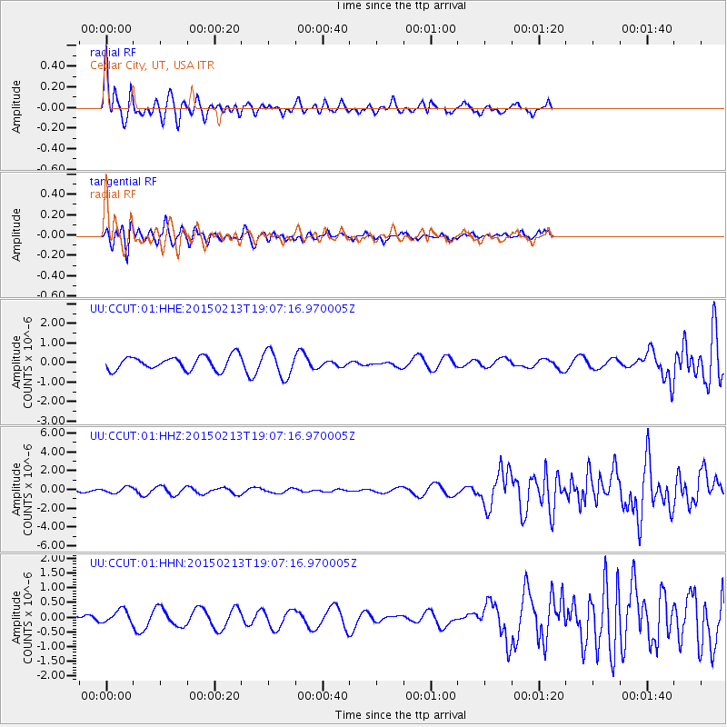
Signal To Noise
| Channel | StoN | STA | LTA |
| UU:CCUT:01:HHZ:20150213T19:07:16.970005Z | 0.96777064 | 3.1058713E-7 | 3.2093052E-7 |
| UU:CCUT:01:HHN:20150213T19:07:16.970005Z | 1.340312 | 2.2555525E-7 | 1.6828564E-7 |
| UU:CCUT:01:HHE:20150213T19:07:16.970005Z | 1.9632922 | 6.7301903E-7 | 3.4280126E-7 |
| Arrivals |
| Ps | 4.8 SECOND |
| PpPs | 17 SECOND |
| PsPs/PpSs | 22 SECOND |


