You are here: Home > Network List > G - GEOSCOPE Stations List
> Station TAOE Taiohae, Marquises islands > Earthquake Result Viewer
TAOE Taiohae, Marquises islands - Earthquake Result Viewer
| Earthquake location: |
Solomon Islands |
| Earthquake latitude/longitude: |
-6.7/154.9 |
| Earthquake time(UTC): |
2014/04/19 (109) 13:27:59 GMT |
| Earthquake Depth: |
31 km |
| Earthquake Magnitude: |
7.5 MWW, 7.8 MI |
| Earthquake Catalog/Contributor: |
NEIC PDE/NEIC COMCAT |
|
| Network: |
G GEOSCOPE |
| Station: |
TAOE Taiohae, Marquises islands |
| Lat/Lon: |
8.85 S/140.15 W |
| Elevation: |
800 m |
|
| Distance: |
64.3 deg |
| Az: |
96.577 deg |
| Baz: |
266.787 deg |
| Ray Param: |
0.05896962 |
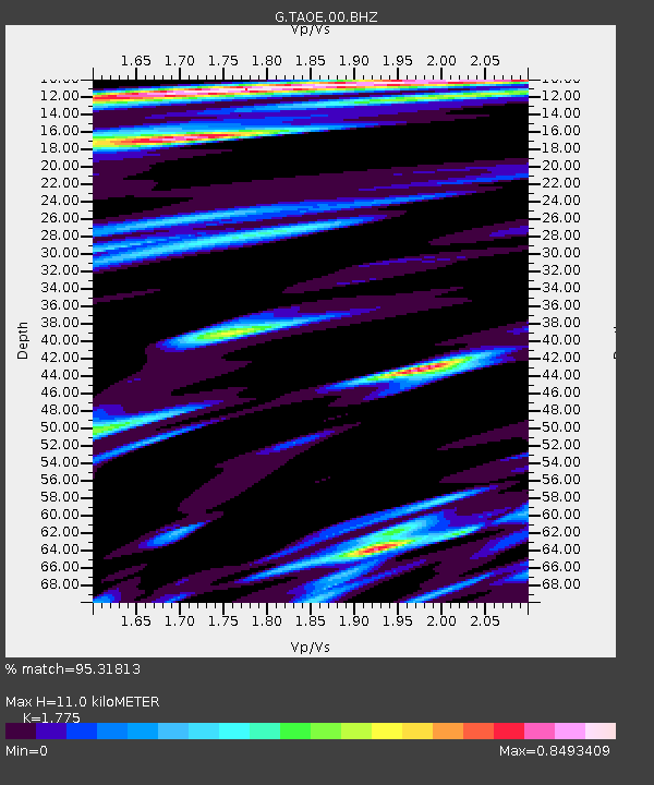
| Estimated Moho Depth: |
11.0 km |
| Estimated Crust Vp/Vs: |
1.77 |
| Assumed Crust Vp: |
4.24 km/s |
| Estimated Crust Vs: |
2.389 km/s |
| Estimated Crust Poisson's Ratio: |
0.27 |
|
| Radial Match: |
95.31813 % |
| Radial Bump: |
338 |
| Transverse Match: |
70.02134 % |
| Transverse Bump: |
400 |
| SOD ConfigId: |
626651 |
| Insert Time: |
2014-05-03 13:50:57.255 +0000 |
| GWidth: |
2.5 |
| Max Bumps: |
400 |
| Tol: |
0.001 |
|
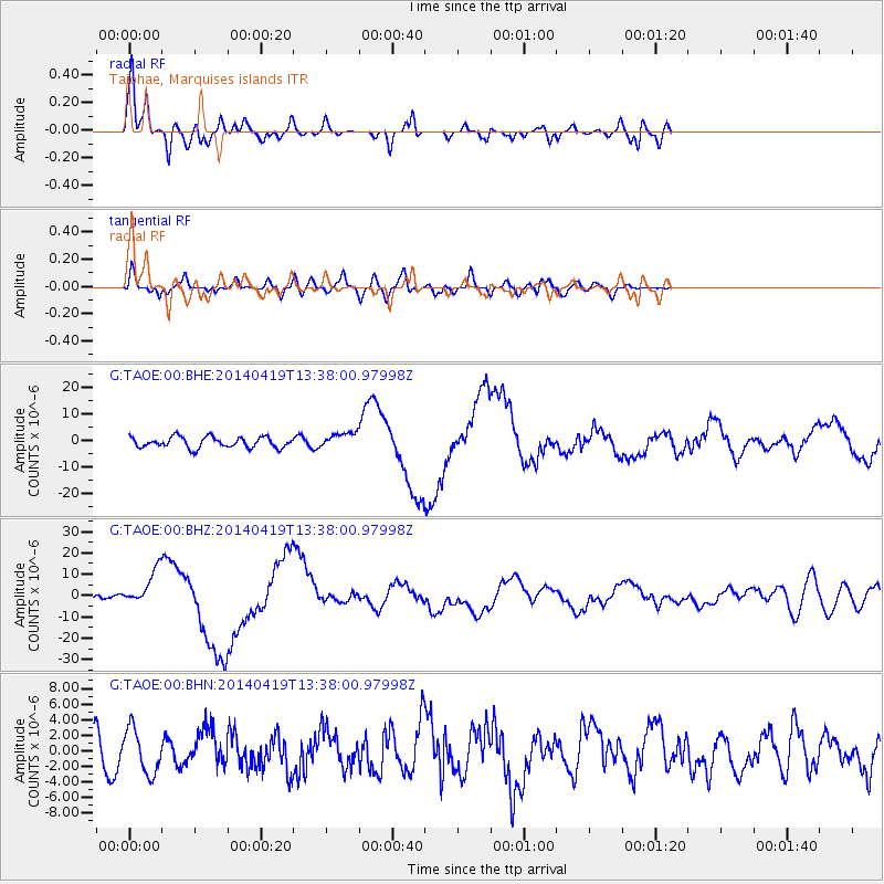
Signal To Noise
| Channel | StoN | STA | LTA |
| G:TAOE:00:BHZ:20140419T13:38:00.97998Z | 2.7119641 | 8.152123E-6 | 3.005985E-6 |
| G:TAOE:00:BHN:20140419T13:38:00.97998Z | 1.237367 | 2.8652482E-6 | 2.315601E-6 |
| G:TAOE:00:BHE:20140419T13:38:00.97998Z | 1.4312739 | 2.895169E-6 | 2.0227917E-6 |
| Arrivals |
| Ps | 2.0 SECOND |
| PpPs | 7.1 SECOND |
| PsPs/PpSs | 9.1 SECOND |


