You are here: Home > Network List > WI - West Indies IPGP Network Stations List
> Station DSLB Salisbury, Dominica > Earthquake Result Viewer
DSLB Salisbury, Dominica - Earthquake Result Viewer
| Earthquake location: |
Northern Mid-Atlantic Ridge |
| Earthquake latitude/longitude: |
52.5/-31.7 |
| Earthquake time(UTC): |
2015/02/13 (044) 18:58:05 GMT |
| Earthquake Depth: |
12 km |
| Earthquake Magnitude: |
4.9 mb |
| Earthquake Catalog/Contributor: |
ISC/ISC |
|
| Network: |
WI West Indies IPGP Network |
| Station: |
DSLB Salisbury, Dominica |
| Lat/Lon: |
15.44 N/61.42 W |
| Elevation: |
324 m |
|
| Distance: |
43.9 deg |
| Az: |
223.655 deg |
| Baz: |
25.931 deg |
| Ray Param: |
0.072269514 |
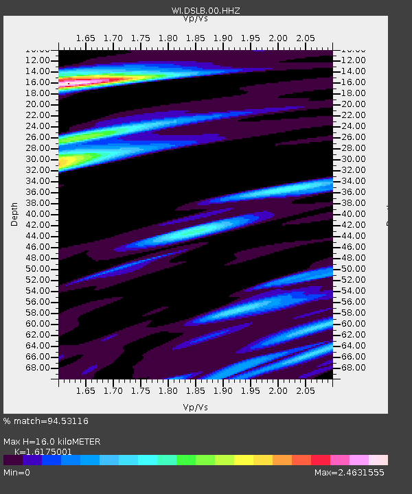
| Estimated Moho Depth: |
16.0 km |
| Estimated Crust Vp/Vs: |
1.62 |
| Assumed Crust Vp: |
5.88 km/s |
| Estimated Crust Vs: |
3.635 km/s |
| Estimated Crust Poisson's Ratio: |
0.19 |
|
| Radial Match: |
94.53116 % |
| Radial Bump: |
400 |
| Transverse Match: |
90.951004 % |
| Transverse Bump: |
400 |
| SOD ConfigId: |
7019011 |
| Insert Time: |
2019-04-16 19:19:03.608 +0000 |
| GWidth: |
2.5 |
| Max Bumps: |
400 |
| Tol: |
0.001 |
|

Signal To Noise
| Channel | StoN | STA | LTA |
| WI:DSLB:00:HHZ:20150213T19:05:40.769993Z | 0.6068837 | 1.8504066E-7 | 3.04903E-7 |
| WI:DSLB:00:HHN:20150213T19:05:40.769993Z | 0.97552156 | 4.5028554E-7 | 4.6158442E-7 |
| WI:DSLB:00:HHE:20150213T19:05:40.769993Z | 1.32497 | 5.85866E-7 | 4.4217305E-7 |
| Arrivals |
| Ps | 1.8 SECOND |
| PpPs | 6.7 SECOND |
| PsPs/PpSs | 8.5 SECOND |


