You are here: Home > Network List > IU - Global Seismograph Network (GSN - IRIS/USGS) Stations List
> Station XMAS Kiritimati Island, Republic of Kiribati > Earthquake Result Viewer
XMAS Kiritimati Island, Republic of Kiribati - Earthquake Result Viewer

| Earthquake location: |
Solomon Islands |
| Earthquake latitude/longitude: |
-6.7/154.9 |
| Earthquake time(UTC): |
2014/04/19 (109) 13:27:59 GMT |
| Earthquake Depth: |
31 km |
| Earthquake Magnitude: |
7.5 MWW, 7.8 MI |
| Earthquake Catalog/Contributor: |
NEIC PDE/NEIC COMCAT |
|
| Network: |
IU Global Seismograph Network (GSN - IRIS/USGS) |
| Station: |
XMAS Kiritimati Island, Republic of Kiribati |
| Lat/Lon: |
2.04 N/157.45 W |
| Elevation: |
20 m |
|
| Distance: |
48.3 deg |
| Az: |
81.259 deg |
| Baz: |
259.205 deg |
| Ray Param: |
0.06937756 |
| Estimated Moho Depth: |
10.0 km |
| Estimated Crust Vp/Vs: |
1.77 |
| Assumed Crust Vp: |
4.802 km/s |
| Estimated Crust Vs: |
2.709 km/s |
| Estimated Crust Poisson's Ratio: |
0.27 |
|
| Radial Match: |
95.04915 % |
| Radial Bump: |
327 |
| Transverse Match: |
70.06805 % |
| Transverse Bump: |
400 |
| SOD ConfigId: |
626651 |
| Insert Time: |
2014-05-03 13:54:58.150 +0000 |
| GWidth: |
2.5 |
| Max Bumps: |
400 |
| Tol: |
0.001 |
|
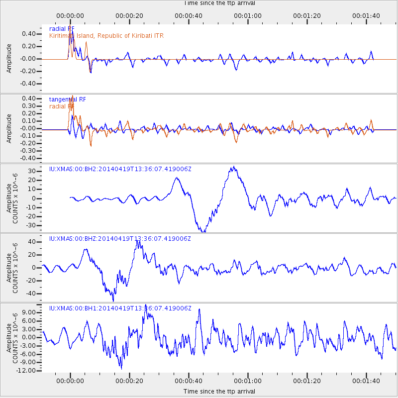
Signal To Noise
| Channel | StoN | STA | LTA |
| IU:XMAS:00:BHZ:20140419T13:36:07.419006Z | 4.404994 | 1.15091825E-5 | 2.612758E-6 |
| IU:XMAS:00:BH1:20140419T13:36:07.419006Z | 1.0480787 | 1.7491302E-6 | 1.6688922E-6 |
| IU:XMAS:00:BH2:20140419T13:36:07.419006Z | 2.6920779 | 5.672133E-6 | 2.106972E-6 |
| Arrivals |
| Ps | 1.7 SECOND |
| PpPs | 5.6 SECOND |
| PsPs/PpSs | 7.3 SECOND |


