You are here: Home > Network List > IW - Intermountain West Stations List
> Station DLMT Dillon, Montana, USA > Earthquake Result Viewer
DLMT Dillon, Montana, USA - Earthquake Result Viewer
| Earthquake location: |
Solomon Islands |
| Earthquake latitude/longitude: |
-6.7/154.9 |
| Earthquake time(UTC): |
2014/04/19 (109) 13:27:59 GMT |
| Earthquake Depth: |
31 km |
| Earthquake Magnitude: |
7.5 MWW, 7.8 MI |
| Earthquake Catalog/Contributor: |
NEIC PDE/NEIC COMCAT |
|
| Network: |
IW Intermountain West |
| Station: |
DLMT Dillon, Montana, USA |
| Lat/Lon: |
45.36 N/112.60 W |
| Elevation: |
1569 m |
|
| Distance: |
96.5 deg |
| Az: |
45.142 deg |
| Baz: |
267.025 deg |
| Ray Param: |
0.040492084 |
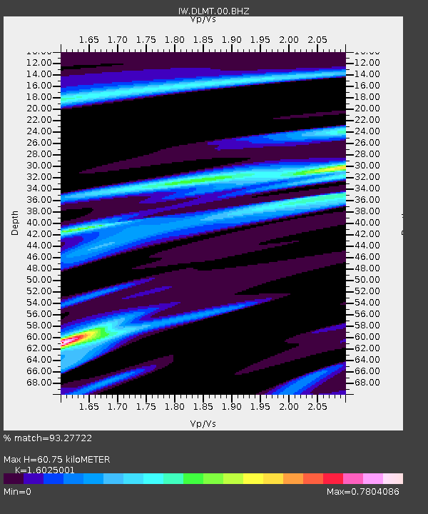
| Estimated Moho Depth: |
60.75 km |
| Estimated Crust Vp/Vs: |
1.60 |
| Assumed Crust Vp: |
6.577 km/s |
| Estimated Crust Vs: |
4.104 km/s |
| Estimated Crust Poisson's Ratio: |
0.18 |
|
| Radial Match: |
93.27722 % |
| Radial Bump: |
400 |
| Transverse Match: |
76.13357 % |
| Transverse Bump: |
400 |
| SOD ConfigId: |
626651 |
| Insert Time: |
2014-05-03 13:55:01.443 +0000 |
| GWidth: |
2.5 |
| Max Bumps: |
400 |
| Tol: |
0.001 |
|
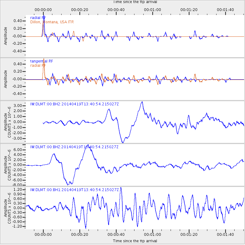
Signal To Noise
| Channel | StoN | STA | LTA |
| IW:DLMT:00:BHZ:20140419T13:40:54.215027Z | 15.218167 | 1.2019343E-6 | 7.8980236E-8 |
| IW:DLMT:00:BH1:20140419T13:40:54.215027Z | 0.32576862 | 6.28094E-8 | 1.9280372E-7 |
| IW:DLMT:00:BH2:20140419T13:40:54.215027Z | 2.0469143 | 4.2976743E-7 | 2.0995867E-7 |
| Arrivals |
| Ps | 5.7 SECOND |
| PpPs | 23 SECOND |
| PsPs/PpSs | 29 SECOND |


