You are here: Home > Network List > JP - Japan Meteorological Agency Seismic Network Stations List
> Station JNU Oita Nakatsue > Earthquake Result Viewer
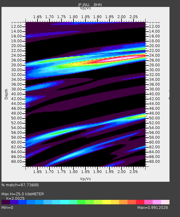
JNU Oita Nakatsue - Earthquake Result Viewer
| Earthquake location: |
Solomon Islands |
| Earthquake latitude/longitude: |
-6.7/154.9 |
| Earthquake time(UTC): |
2014/04/19 (109) 13:27:59 GMT |
| Earthquake Depth: |
31 km |
| Earthquake Magnitude: |
7.5 MWW, 7.8 MI |
| Earthquake Catalog/Contributor: |
NEIC PDE/NEIC COMCAT |
|
| Network: |
JP Japan Meteorological Agency Seismic Network |
| Station: |
JNU Oita Nakatsue |
| Lat/Lon: |
33.12 N/130.88 E |
| Elevation: |
540 m |
|
| Distance: |
45.7 deg |
| Az: |
331.474 deg |
| Baz: |
145.581 deg |
| Ray Param: |
0.07101659 |
| Estimated Moho Depth: |
25.0 km |
| Estimated Crust Vp/Vs: |
2.00 |
| Assumed Crust Vp: |
6.468 km/s |
| Estimated Crust Vs: |
3.23 km/s |
| Estimated Crust Poisson's Ratio: |
0.33 |
|
| Radial Match: |
97.73688 % |
| Radial Bump: |
316 |
| Transverse Match: |
93.11697 % |
| Transverse Bump: |
400 |
| SOD ConfigId: |
626651 |
| Insert Time: |
2014-05-03 13:55:39.510 +0000 |
| GWidth: |
2.5 |
| Max Bumps: |
400 |
| Tol: |
0.001 |
|

Signal To Noise
| Channel | StoN | STA | LTA |
| JP:JNU: :BHZ:20140419T13:35:47.299988Z | 32.12365 | 1.2968395E-5 | 4.0370242E-7 |
| JP:JNU: :BHN:20140419T13:35:47.299988Z | 16.022566 | 5.3519866E-6 | 3.340281E-7 |
| JP:JNU: :BHE:20140419T13:35:47.299988Z | 14.127603 | 3.7608297E-6 | 2.6620438E-7 |
| Arrivals |
| Ps | 4.1 SECOND |
| PpPs | 11 SECOND |
| PsPs/PpSs | 15 SECOND |


