You are here: Home > Network List > YQ13 - Study of Extension and Magmatism in Malawi and Tanzania Stations List
> Station KAPO Kaporo,Malawi > Earthquake Result Viewer
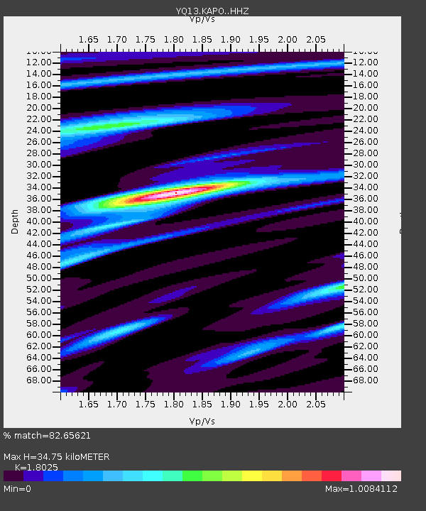
KAPO Kaporo,Malawi - Earthquake Result Viewer
| Earthquake location: |
Northern Mid-Atlantic Ridge |
| Earthquake latitude/longitude: |
52.5/-31.7 |
| Earthquake time(UTC): |
2015/02/13 (044) 18:58:05 GMT |
| Earthquake Depth: |
12 km |
| Earthquake Magnitude: |
4.9 mb |
| Earthquake Catalog/Contributor: |
ISC/ISC |
|
| Network: |
YQ Study of Extension and Magmatism in Malawi and Tanzania |
| Station: |
KAPO Kaporo,Malawi |
| Lat/Lon: |
9.79 S/33.82 E |
| Elevation: |
533 m |
|
| Distance: |
83.3 deg |
| Az: |
115.442 deg |
| Baz: |
325.966 deg |
| Ray Param: |
0.046254434 |
| Estimated Moho Depth: |
34.75 km |
| Estimated Crust Vp/Vs: |
1.80 |
| Assumed Crust Vp: |
6.502 km/s |
| Estimated Crust Vs: |
3.607 km/s |
| Estimated Crust Poisson's Ratio: |
0.28 |
|
| Radial Match: |
82.65621 % |
| Radial Bump: |
400 |
| Transverse Match: |
80.17157 % |
| Transverse Bump: |
400 |
| SOD ConfigId: |
7019011 |
| Insert Time: |
2019-04-16 19:20:27.677 +0000 |
| GWidth: |
2.5 |
| Max Bumps: |
400 |
| Tol: |
0.001 |
|

Signal To Noise
| Channel | StoN | STA | LTA |
| YQ:KAPO: :HHZ:20150213T19:10:00.840Z | 0.8332064 | 8.294623E-8 | 9.955063E-8 |
| YQ:KAPO: :HHN:20150213T19:10:00.840Z | 0.9599486 | 9.2836984E-8 | 9.671037E-8 |
| YQ:KAPO: :HHE:20150213T19:10:00.840Z | 1.0413891 | 1.3855767E-7 | 1.3305082E-7 |
| Arrivals |
| Ps | 4.4 SECOND |
| PpPs | 15 SECOND |
| PsPs/PpSs | 19 SECOND |


