You are here: Home > Network List > NN - Western Great Basin/Eastern Sierra Nevada Stations List
> Station WAK Walker, California w84 > Earthquake Result Viewer
WAK Walker, California w84 - Earthquake Result Viewer
| Earthquake location: |
Solomon Islands |
| Earthquake latitude/longitude: |
-6.7/154.9 |
| Earthquake time(UTC): |
2014/04/19 (109) 13:27:59 GMT |
| Earthquake Depth: |
31 km |
| Earthquake Magnitude: |
7.5 MWW, 7.8 MI |
| Earthquake Catalog/Contributor: |
NEIC PDE/NEIC COMCAT |
|
| Network: |
NN Western Great Basin/Eastern Sierra Nevada |
| Station: |
WAK Walker, California w84 |
| Lat/Lon: |
38.50 N/119.44 W |
| Elevation: |
1890 m |
|
| Distance: |
90.7 deg |
| Az: |
51.479 deg |
| Baz: |
262.06 deg |
| Ray Param: |
0.041649118 |
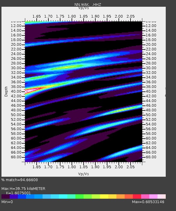
| Estimated Moho Depth: |
39.75 km |
| Estimated Crust Vp/Vs: |
1.61 |
| Assumed Crust Vp: |
6.279 km/s |
| Estimated Crust Vs: |
3.906 km/s |
| Estimated Crust Poisson's Ratio: |
0.18 |
|
| Radial Match: |
94.66608 % |
| Radial Bump: |
400 |
| Transverse Match: |
77.6847 % |
| Transverse Bump: |
400 |
| SOD ConfigId: |
626651 |
| Insert Time: |
2014-05-03 13:57:49.907 +0000 |
| GWidth: |
2.5 |
| Max Bumps: |
400 |
| Tol: |
0.001 |
|

Signal To Noise
| Channel | StoN | STA | LTA |
| NN:WAK: :HHZ:20140419T13:40:27.965027Z | 5.160633 | 1.2926937E-6 | 2.504913E-7 |
| NN:WAK: :HHN:20140419T13:40:27.965027Z | 0.47614592 | 8.099519E-8 | 1.701058E-7 |
| NN:WAK: :HHE:20140419T13:40:27.965027Z | 2.6674917 | 4.276061E-7 | 1.6030269E-7 |
| Arrivals |
| Ps | 3.9 SECOND |
| PpPs | 16 SECOND |
| PsPs/PpSs | 20 SECOND |


