You are here: Home > Network List > TA - USArray Transportable Network (new EarthScope stations) Stations List
> Station 109C Camp Elliot, Mirimar, CA, USA > Earthquake Result Viewer
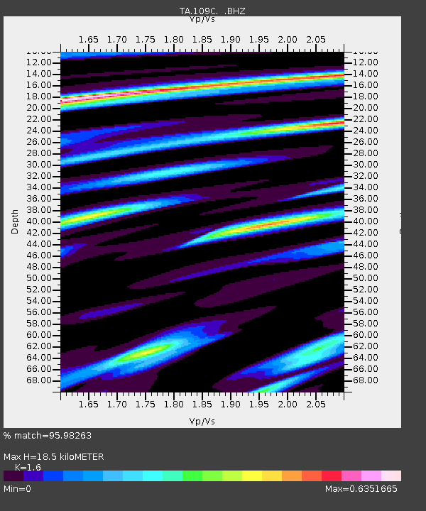
109C Camp Elliot, Mirimar, CA, USA - Earthquake Result Viewer
| Earthquake location: |
Solomon Islands |
| Earthquake latitude/longitude: |
-6.7/154.9 |
| Earthquake time(UTC): |
2014/04/19 (109) 13:27:59 GMT |
| Earthquake Depth: |
31 km |
| Earthquake Magnitude: |
7.5 MWW, 7.8 MI |
| Earthquake Catalog/Contributor: |
NEIC PDE/NEIC COMCAT |
|
| Network: |
TA USArray Transportable Network (new EarthScope stations) |
| Station: |
109C Camp Elliot, Mirimar, CA, USA |
| Lat/Lon: |
32.89 N/117.11 W |
| Elevation: |
150 m |
|
| Distance: |
91.9 deg |
| Az: |
57.279 deg |
| Baz: |
263.284 deg |
| Ray Param: |
0.041532356 |
| Estimated Moho Depth: |
18.5 km |
| Estimated Crust Vp/Vs: |
1.60 |
| Assumed Crust Vp: |
6.264 km/s |
| Estimated Crust Vs: |
3.915 km/s |
| Estimated Crust Poisson's Ratio: |
0.18 |
|
| Radial Match: |
95.98263 % |
| Radial Bump: |
332 |
| Transverse Match: |
83.84695 % |
| Transverse Bump: |
400 |
| SOD ConfigId: |
626651 |
| Insert Time: |
2014-05-03 14:00:24.655 +0000 |
| GWidth: |
2.5 |
| Max Bumps: |
400 |
| Tol: |
0.001 |
|

Signal To Noise
| Channel | StoN | STA | LTA |
| TA:109C: :BHZ:20140419T13:40:33.393982Z | 2.7692375 | 1.1382026E-6 | 4.1101663E-7 |
| TA:109C: :BHN:20140419T13:40:33.393982Z | 2.9520483 | 3.5154383E-7 | 1.1908471E-7 |
| TA:109C: :BHE:20140419T13:40:33.393982Z | 2.7062984 | 4.6069297E-7 | 1.7022992E-7 |
| Arrivals |
| Ps | 1.8 SECOND |
| PpPs | 7.5 SECOND |
| PsPs/PpSs | 9.3 SECOND |


