You are here: Home > Network List > TA - USArray Transportable Network (new EarthScope stations) Stations List
> Station A36M Sachs Harbour, NT, CAN > Earthquake Result Viewer
A36M Sachs Harbour, NT, CAN - Earthquake Result Viewer

| Earthquake location: |
Solomon Islands |
| Earthquake latitude/longitude: |
-6.7/154.9 |
| Earthquake time(UTC): |
2014/04/19 (109) 13:27:59 GMT |
| Earthquake Depth: |
31 km |
| Earthquake Magnitude: |
7.5 MWW, 7.8 MI |
| Earthquake Catalog/Contributor: |
NEIC PDE/NEIC COMCAT |
|
| Network: |
TA USArray Transportable Network (new EarthScope stations) |
| Station: |
A36M Sachs Harbour, NT, CAN |
| Lat/Lon: |
71.99 N/125.25 W |
| Elevation: |
32 m |
|
| Distance: |
93.2 deg |
| Az: |
17.86 deg |
| Baz: |
258.27 deg |
| Ray Param: |
0.04129734 |
| Estimated Moho Depth: |
21.5 km |
| Estimated Crust Vp/Vs: |
1.91 |
| Assumed Crust Vp: |
6.24 km/s |
| Estimated Crust Vs: |
3.263 km/s |
| Estimated Crust Poisson's Ratio: |
0.31 |
|
| Radial Match: |
96.842834 % |
| Radial Bump: |
400 |
| Transverse Match: |
85.99437 % |
| Transverse Bump: |
400 |
| SOD ConfigId: |
626651 |
| Insert Time: |
2014-05-03 14:00:35.930 +0000 |
| GWidth: |
2.5 |
| Max Bumps: |
400 |
| Tol: |
0.001 |
|
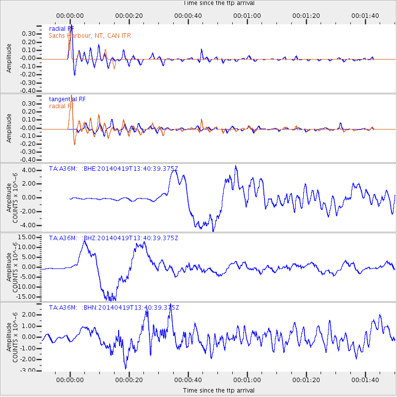
Signal To Noise
| Channel | StoN | STA | LTA |
| TA:A36M: :BHZ:20140419T13:40:39.375Z | 50.918842 | 5.8965916E-6 | 1.1580372E-7 |
| TA:A36M: :BHN:20140419T13:40:39.375Z | 2.5702717 | 5.230417E-7 | 2.0349665E-7 |
| TA:A36M: :BHE:20140419T13:40:39.375Z | 13.428477 | 1.6782103E-6 | 1.24974E-7 |
| Arrivals |
| Ps | 3.2 SECOND |
| PpPs | 9.9 SECOND |
| PsPs/PpSs | 13 SECOND |


